BEST EXCUSE TO PLAY HOOKY
Boulder Arts and Crafts Cooperative

- 1421 Pearl St., Boulder, 80302 Map
- 303-443-3683
- www.boulderartsandcrafts.com
BEST NEW JOB FOR GOVERNOR BILL OWENS
Mid-term replacement for Vice President Dick Cheney
BEST PROOF THAT DENVER SPORTS FANS ARE PRETTY DAMN POLITE
"Suit up, you chump!"
BEST TICKET WINDOW
Red Rocks Drive-Thru Box Office Red Rocks Park Rd., Entrance 2
BEST FREE SERVICE
Easter Sunrise at Red Rocks
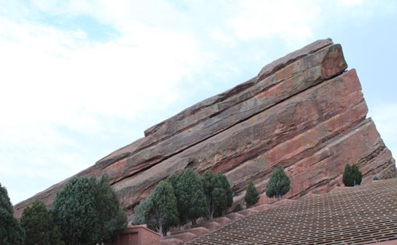
- 18300 W. Alameda Parkway, Morrison, 80465 Map
- 720-865-2494
- www.redrocksonline.com
BEST HOMEGROWN CHOCOLATE
Chocolove 1-888-Chocolove
BEST NEW JOB FOR DAN HOPKINS
Spokesman for Marc Holtzman
This Place
By Drew Bixby
There was a time, two fearless minds where we packed up for a new place A college town with a musical sound And everyone had a new face There was something there Maybe it was the trees Or the flowery air Or that everyone seemed so glad They were there And we were two of those too -- from "Two of Those Too," by Maria Taylor
August 1, 2005, was quiet and overcast in Iowa City, my home of five years. I woke up early and was immediately conscious of how heavy everything felt. The air. My heart. By 11 a.m., my girlfriend and I had packed the last few things from our apartment into her car and the ten-foot trailer we'd rented for the move west. Then we drove. For the first twenty or so miles of the 800-mile trek to Denver, we said nothing. Alone with my thoughts and the introspective Maria Taylor songs that drifted around the car, I thought about the Midwest -- about the lost loves and spilled blood that continued to define me; about the explosive autumns that smelled of cool air and open fire and had brought every one of my 22 birthdays. I thought about the only home I had ever known, and I cried because I felt so terrible for leaving her.
Six months earlier, Maggie and I had decided it was time to leave the Midwest. The cold and cloudy winters made us tired; the faces in our favorite bars were becoming increasingly unfamiliar; our friends were moving on to other things. We realized that we needed to see what else was out there. So we talked about where we could see ourselves living, where we thought we could make a new life. At random, we chose Denver, a city where we knew no one, a city I'd never even visited. Maybe we were moved by the stories about the sunshine and the mountains, or reports of a lively yet laid-back lifestyle. Maybe it was simply the mystery of the place. However we reached that decision, we set our hearts on Colorado.
August 2, 2005, was hot and dry and sunny and everything I had dreamed Denver would be in mid-summer. Somewhere near the Nebraska/Colorado border, I'd stopped hankering for the lakes and rolling plains I'd abandoned back in Illinois (where I'd grown up) and Iowa, and began pining for the mountains and the microbrews I'd never experienced. A random exit onto Colorado Boulevard and a right turn onto Colfax led us to beers and lunch on the patio of the Irish Snug, now one of my favorite bars in Capitol Hill.
Our subsequent apartment hunt was grueling as we navigated the Hill’s narrow streets with the car and trailer. We must have looked at twenty apartments and talked to twice as many landlords before we finally found a place near Cheesman Park with a breathtaking view of the downtown skyline and the mountains. I loved the Hill immediately for its tall trees and green lawns, its old houses and apartment buildings filled with character and charm. As the sun was setting on our first day in Denver, we returned to the Snug for beers and dinner on the patio, then a walk down Colfax toward the State Capitol. Somewhere near Pearl Street, I realized I was falling for this transient neighborhood of bodegas and bars and liquor stores and coffee shops -- Playboy's favorite wicked street. It could have been the Sunshine Wheat combined with the altitude, but six hours after we blew into town, I already felt like I was home.
I've always been acutely aware of the significance that accompanies time and place. Because of this, I consider my home not just the place where I live, but a reflection on who I am and who I’m becoming. Now, nearly eight months since we arrived in town with no place to live and no friends to greet us, I feel Denver becoming more and more a part of me.
Initially, I loved Denver for the pockets of character located in or around Capitol Hill: Pete’s Kitchen, Hooked on Colfax, the Atomic Cowboy and the Fabric Lab, as well as every other inch of Colfax between Broadway and Colorado; the Queen Soopers and Diedrich Coffee at Ninth and Corona; Wax Trax, Bender's, Liks and Rare Bird on Thirteenth; the Tavern and Chedd’s in Uptown. I rejoiced that, with the exception of the inevitable Starbucks, Blockbusters and Taco Bells, central Denver was winning the war against big-box stores and franchises and the homogenization that plagues cities and suburbs across the country.
With time, I worked my way out to the Mayan and all the randomness that is South Broadway, the arts district and First Fridays on Santa Fe, the Highland neighborhood and all those authentic Mexican restaurants west of I-25, and even a few places in LoDo where I can stand to be after dark – the Tattered Cover, Illegal Pete's. And I toured Denver's best music joints: the Larimer Lounge, Cricket on the Hill and the hi-dive, which all remind me of the small dive clubs in Chicago and Iowa City; the Gothic and the Bluebird, proof that Denver is at least attempting to maintain and celebrate its history and culture; and the Fillmore, which I loathe for its amphitheater-priced beer but occasionally adore for the bands that play there.
But as much as I appreciate local commerce and culture, I've become enchanted with Denver's easy access to the mountains and its sun-drenched, moderate climate. At times when I'd normally be forced indoors in the Midwest, I've found myself sitting by the lake in Washington Park, playing kickball in Congress Park or walking laps around Cheesman Park.
There is a part of me that will always be inherently Midwestern. It’s who I am and where I come from; I can’t deny that. But the more I explore and discover this vibrant city, the more difficult it becomes to deny that this place of mountains and microbrews has become my home. In just a matter of months, Denver has managed to tame me and win my heart -- if not forever, then close enough.
Things Change
By Alan Prendergast
It’s been more than twenty years since I first came across "High Treason,” a short lesson in patriotism by Mexican poet José Emilio Pacheco. The poem begins with Pacheco’s declaration that he doesn’t love his country; its “abstract splendors” elude him. Yet, he goes on,
I would give my life
for ten places in it, for certain people,
seaports, pinewoods, fortresses,
a run-down city, gray, grotesque,
various figures from its history,
mountains
(and three or four rivers).
I was introduced to the poem by Alastair Reid, known for his translations of Borges and Neruda. I'd met Reid while I was at Colorado College, then looked him up in New York City after graduation. Everyone I knew seemed to be heading there, eager to lose their provincialism in the Big Apple orgy of art, film, music, culture -- and kick-start their brilliant careers with absurdly underpaid jobs as editorial assistants, advertising flunkies and junior execs in training.
Reid, a kindhearted Scot who never seemed to stay in one place for long, showed me the poem -- and, not long after, helped me land a job in the mailroom of The New Yorker. For a few weeks, I was the envy of all my fellow wage slaves, who wanted me to slip their pained, Carveresque stories under the fiction editor's door and drop their Scorsese-like screenplays on Pauline Kael's desk.
But I soon decided that the ultimate city wasn't for me. Manhattan, it turned out, was an incredibly provincial place -- wrapped up in itself, with quaint and generally disparaging notions of the rest of the world. (The famous Saul Steinberg cartoon, with its casual dismissal of the vast wasteland beyond the Hudson River, says it all.) I missed big skies, purple mountains, the open road, Mexican food. Colorado is in my blood. I am, quite simply, a Denver person -- by birth and by choice. Aside from school, vacations, a few extended road trips and pilgrimages and the usual post-collegiate meandering, I have spent my entire life here.
Why do I stay? Family, friends and work are big reasons, but not the only ones. Denver's enduring charms are part of the equation, but so are some of the startling changes that have transformed the place over the past quarter-century. You have to take the yin with the yang. Otherwise you end up like those poor souls who, at the start of every growth spasm, slap a "Native" sticker on their car and bitch about all the traffic and sprawl -- then quietly slip away in the night, pocketing the scandalous surge in their property values. Or, worse yet, like the flat-eyed speculators who breeze into town, determined to cash in on the coming bonanza, only to decamp a few months later, cursing this cowtown for its fickleness.
It would be easy to lament the lost Denver of my childhood, a place of pristine air and little congestion. Easy -- and dishonest. In those days, the local concept of sophisticated cuisine was embodied in the hideous Yum Yum Tree, a cafeteria of pseudo-ethnic glop on Colorado Boulevard, and nightlife didn't extend much beyond funky supper clubs and Sid King's burlesque shows. Does anyone really want to turn Confluence Park back into the sewer it was before the condo developers, REI and Elitch's came along? Want to trade Belmar for Villa Italia? LoDo for Skid Row? How about the current sports scene for the pre-1976 Denver Broncos?
When visitors come to town, I like to show them the "new" Denver, just to watch them try to process it. ("Oh, this is like Portland…or like…well, maybe not…") We buy gelato at Ink! and study the evolving downtown skyline from the Millennium Bridge, while coal trains rumble below and the light rail toodles from Union Station to Littleton, honking its toy horn. We check out the emerging radical collective that is South Broadway and the too-precious shopping and snacking opportunities of the Highland neighborhood.
But I also try to give them a taste of the old burg, many of the best parts of which still survive: lunch at the Buckhorn Exchange (mind those beastly heads) or dinner at the Fort. Drinks in the fabulous atrium of the Brown Palace. Visits to the Tattered Cover and Germinal Stage, venerable independent enterprises fueled by warhorses who never let a little thing like the economy get in their way. The National Western Stock Show. The Kirkland Museum and the chile rellenos at La Fiesta. The stately Denver squares of Capitol Hill, where I grew up, and the splendiferous esplanade of East High, where I encountered amazing teachers and great books and started conversations about art and life with dear friends that still continue today.
For all its upheaval, Denver remains an incredibly manageable city. It's not the kind of place where you have to steel yourself for a three-hour commute (unless you're from L.A. and really prefer that kind of thing) or fight like hell just to hang on to a broom closet of personal space. It's navigable, alive and human. Unlike many Western cities, it's held on to much of its past and a vibrant downtown; unlike so many cities in the Rust Belt, it has a future, too. Certainly it's fared better than most of its own suburbs, which have been slow to develop any sort of character themselves, other than the kind provided by big-box stores and multiplex cinemas.
That's okay. Let Highlands Ranch be Highlands Ranch, whatever that is. I don't know if I love what Denver has become, but I know I love many places in it, certain people, various memories and ghosts from its past, a river or two, three or four mountains.
The list gets longer every day.
BEST PRE-RED ROCKS STOP
The Blue Cow
- 316 Bear Creek Ave., Morrison, 80465 Map
- 303-697-5721
- thecoweatery.com/
BEST SPIRIT CORPS
Montbello High School
Best Of Denver®

Do Not Sell or Share My Information
