How much snow will the Front Range see this winter? We've looked at some clues that Mother Nature is already sprinkling around about Colorado's next snow season, and it starts, of course...in the equatorial Pacific Ocean.
Wait, what?
One of the first things we consider is a possible El Niño or La Niña, the former made famous by Chris Farley back in the 1990s. You've probably heard of it, but what is it, exactly?
Simply put, El Niño is the presence of warmer than usual sea-surface temperatures in the central Pacific Ocean, and La Niña is, as you probably guessed, the opposite, or cooler-than-usual sea-surface temperatures in the same area. An El Niño or a La Niña, especially a strong one, leads to a global meteorological domino effect of varying conditions. This is a relatively new discovery and imperfect science, but it gives us some decent, albeit general, clues about how Mother Nature might behave.

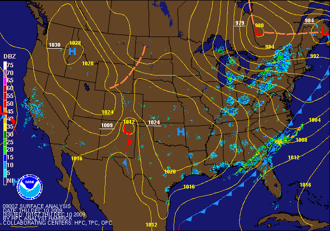
A classic low track for a big Denver snowstorm, from December 2009.
National Oceanic and Atmospheric Administration (NOAA)
See the nearly continuous blue line along the equator, from the western coast of South America (about 70W) to just about Asia, or 180º longitude? That's a long stretch of cooler-than-average Pacific sea surface temperatures, or a pretty clear indicator that we're looking at a La Niña in formation, if not close to already here. A La Niña Watch is in place, meaning conditions are favorable for a La Niña to form. The National Oceanic and Atmospheric Administration is putting the odds of a La Niña this winter at about 55 to 60 percent, with most signs pointing to one developing.
What does a likely La Niña signify for Colorado? Typically, a La Niña year tends to shift storm tracks toward the Pacific Northwest, as a big "blocking" area of high pressure in the Gulf of Alaska steers storms through the Alaskan panhandle, southwestern Canada and into the northern Rockies.
This is probably good news for places like Steamboat Springs, Winter Park and the ski resorts along Interstate 70, which recognize that rainy days in Seattle and Portland turn into their main source for champagne powder. For Denver, however, the impacts will probably be substantially different. Our big snowstorms in the Mile High City tend to come from storms moving through California and the Southwest, and tracking through New Mexico and southern Colorado. These types of storms tend to be less common in La Niña years because storm concentration is focused further north. Below is an example of one from December 2009: Follow the red "L" moving through California, southern Utah and Colorado, and ultimately leading to big snow in Denver.

That said, the jet stream (the purple line in the map above), a narrow band of really strong winds at the upper levels of the atmosphere that dictates a lot of our weather, tends to dive through our region a bit more often. That can set up localized but sometimes significant snow events, such as the one that led to Denver's biggest snow last winter, an 8-inch event on December 15-16.
The last big La Niña, though, led to a huge snow deficit in Denver in 2010-11, when we only saw a total of 22.8 inches, the third-lowest total on record (and the lowest seasonal snow total since 1888-89, back when Grover Cleveland was president).
In years with reliable El Niño/La Niña (officially termed ENSO, or El Niño-Southern Oscillation) records, twenty recorded some form of a La Niña. Of those twenty years, only four resulted in above-average snowfall for Denver. In the eleven years with a moderate or strong La Niña, Denver has only had one above-average snowfall season. On top of that, during those eleven years, Denver averaged a little over six inches below the historical seasonal snowfall average of 57.1 inches.
Most computer models, as indicated in the chart below, forecast Pacific sea-surface temperatures to drop into the moderate La Niña range.
Based on these broad clues, we could be looking at a slightly less-than-average snow season for Denver.

But wait, is it gonna snow Monday?
Yes, it looks like it will. Right now, it appears that the city will get a slushy inch or two of wet snow, with higher amounts in the foothills, as usual.
But the snow will probably only stick to your lawn or car top. It's early October, so the sun angle is still pretty high, and that should keep snow off most paved surfaces, especially with temperatures predicted to reach to the low 80s this weekend.