From his desk in Denver’s Traffic Management Center, Mark Meulemans can see buses crawling up East Colfax toward the Capitol. He can also see trucks rumbling through the drizzle at 56th and Dallas, a dense pack of commuters on rain-slicked Colorado Boulevard, a blocks-long queue of cars forming at Alameda and Broadway.
Meulemans may not be all-seeing, but he sees plenty. Located on the fifth floor of the Wellington Webb Building, the TMC features a wall of flat-screens, projecting dozens of shifting images from 502 cameras mounted at intersections across the city. The transportation nerve center receives not just visuals, but a constant stream of data, confirming that traffic lights are working and are properly synched for peak flows, special events or off-peak driving.
“I’m getting a look at the whole city here,” says Meulemans, the TMC’s project manager. “I look at Broadway and downtown a lot to get a feel for how things are going.”
If a problem develops with a particular signal, Meulemans and his staff can examine the situation on the screen before sending out a crew. In the event of an accident or other emergency, Denver police and EMTs rely on the TMC data to help guide their response. Utilities and wastewater employees also keep an eye on the screens when there’s a possibility of flooding or other disruptions. In a few years, city officials hope to have the technology to gather information from individual smart cars and share real-time traffic updates with the motoring public.
All that vigilance is supposed to help keep things moving in the Mile High City. But at the moment, it can’t do much about the sheer volume of traffic — like that bottleneck forming on Alameda, stretching from Broadway down to Santa Fe. Outside of downtown, some signals are semi-actuated, meaning that they maintain green lights on the main drag until waiting traffic or pedestrians are detected on the side street. But you can’t fool with a major signal to speed things up, Meulemans explains, without throwing other parts of the system out of kilter.
Fortunately, traffic is relatively light right now — not bad for four o’clock on a Monday afternoon. The real gruesomeness won’t arrive for another hour or so, when the arterials swell with motorists heading home from work. But small crises are already starting to develop. Meulemans gets a report that some road warrior has taken out a fiber-optic box at Evans and Federal; the screen shows a utility truck on scene and working on repairs. Fortunately, the accident didn’t knock out the traffic signals in the area, just the TMC’s ability to communicate with those signals, which now appear as a small cluster of blue dots amid a sea of green dots on a computer screen.
After a couple of calls, Meulemans seems satisfied that there’s nothing to worry about. The signals will keep running on time, even if the traffic doesn’t. But then, the complexities of Denver’s traffic aren’t something that even a sophisticated monitoring system like this one can solve.
Motorists tend to blame the misery of Denver’s roadways on many factors, from ubiquitous construction to geezers puttering in the passing lane to maniacs tailgating their way into gridlocked intersections. But the driving force, so to speak, is also the most obvious one: the city’s frenetic and largely unanticipated surge in population over the past seven years. Half a million new residents have poured into Colorado since 2010, close to 100,000 of them moving into Denver itself.
Most of those folks brought their cars with them — and, like many of the previous arrivals, settled into housing miles from their workplace, either out of personal preference or economic necessity. Every weekday, 150,000 people travel out of Denver to jobs up and down the Front Range, while 300,000 other commuters head into Denver from the suburbs. One result of that massive migration is the daily impasse we refer to as rush hour, though there’s nothing rushing about it. The amount of time that the average household spent stuck in traffic on the city’s regional freeways and arterials surged from 52 hours a year in 2009 to 66 hours in 2015, a 20 percent hike; the delays are expected to increase another 122 percent by 2035, while the number of places in the road system designated as congested for three or more hours a day is projected to increase by 39 percent.

Mark Meulemans, project manager for Denver’s Traffic Management Center, studies images from intersection cameras around the city as he monitors the afternoon commute.
Anthony Camera
Saying that he found the pace of growth “shocking,” the mayor pledged a series of initiatives to promote affordable housing and unveiled his Mobility Action Plan, which he described as “a clarion call for a future that offers mobility freedom for all.”
His administration’s MAP, the mayor explained, would relieve the congestion, repair crumbling infrastructure, and even help people find and pay for parking on their smartphones. Most of all, it would coax commuters out of their cars and shift them to other means of getting around, by providing them with “the choices we know our residents want to make.”
“We must make it safer and easier to get where we need to go,” Hancock declared. “We’re going to have to get smarter. We’re going to have to get bolder. And we’re going to have to act fast, before gridlock becomes a way of life.”
The speech bristled with bold proclamations, a list of lofty goals without much detail about how they were going to be achieved. Under the new plan, greenhouse gas emissions would be reduced by 80 percent by 2050, thanks largely to the emergence of electric vehicles. The number of commuters driving alone in their cars to work would drop from the current 73 percent — one of the highest rates of single-occupancy-vehicle travel in the country — to 50 percent in the next thirteen years. Most amazing of all, the city would implement new safety measures to reach a goal of “zero traffic deaths” by 2030.
There shall be no death. It was a bit like listening to a commissar declare that it’s always spring in the commune, and next year’s wheat production will be double this year’s, and the year after that it will double again. For perspective, consider that the 2011 Denver Moves plan called for increasing the percentage of commuters who bike or walk to work from 6 to 15 percent by 2020. Six years later, despite the addition of a hundred miles of bike lanes and various pedestrian amenities, the percentage of bicyclists and pedestrians in the mix remains virtually unchanged, at 6.7 percent. The MAP calls for that figure to increase to 15 percent by 2030, giving the planners a decade-long mulligan.
But the city’s mobility plan is more than just lip service to the idea of mobility. Although the document summarizing the initiative strains to reach a mere ten pages, it builds on a stack of previous traffic studies and proposals, from Blueprint Denver to the Hickenlooper administration’s Strategic Transportation Plan to Denver Moves and beyond. And this latest version comes with a hefty price tag: $2 billion, to be spent over the next dozen years. Some of the money is expected to come from an expanding city budget and marijuana tax revenues; another $415 million in transportation projects is included in the $937 million bond issue that Denver voters will be asked to approve next month. Together the bond money and the budget hike come to about $1.65 billion, leaving another $350 million worth of projects on the wish list for which no funding has yet been identified.
Funded or not, the package includes more bike lanes, better sidewalks, bridge repairs, stepped-up speeding enforcement and bus rapid transit on East Colfax. Conspicuously missing is any suggestion of expanding congested thoroughfares to accommodate more cars. In fact, many of the transit and bike projects will require taking more lanes away from auto traffic, in what some critics regard as a behavior-modification strategy, one that attempts to make driving so difficult that commuters are forced to find other ways to travel.
Randal O’Toole, a transportation-policy guru for the Cato Institute and the Independence Institute, calls the city’s proposal an “immobility plan” that will increase congestion and squander millions pursuing unattainable goals. “City planners can’t wave a wand and suddenly double transit ridership and/or walking and cycling,” he writes in a recent critique of the MAP on his Antiplanner blog. “The city should plan for what people will do, not for what planners wish they would do.”“We’re going to have to act fast, before gridlock becomes a way of life.”
tweet this
“We’re not saying everyone needs to walk or bike or take transit all the time,” says Crissy Fanganello, Denver’s transportation director. “But we have to build out a network that gives us the ability to do so, that’s safe and convenient and competitive. It comes down to an issue of space. For the most part, we’re not widening the roads we have. So how do we use our space more efficiently? At the rate of growth we’re experiencing, it’s no longer efficient to move people at the rate of one per vehicle.”
But transit skeptics such as O’Toole aren’t the only ones finding fault with the city’s approach. Some bike and transit advocates regard the MAP approach as not nearly bold enough. Denver currently spends about $2.2 million a year on bike infrastructure. (As of 2017, the Denver Department of Public Works is also budgeting money for sidewalks, which used to be solely the responsibility of property owners.) While that’s triple what the city was spending on bikes as recently as 2013, it’s still a far cry from what more bike-friendly cities spend. If the bond issue passes, the city will have a total of around $5 million a year for new bike lanes and other improvements, but compare that to the current annual bike and pedestrian expenditures by El Paso ($15 million), Oklahoma City ($25 million), Seattle ($30 million) and, yes, Las Vegas ($42 million).
“We like to pat ourselves on the back,” says James Waddell, the executive director of Bike Denver. “We do have some nice trails. But in reality, we’re way behind. At the rate they’re spending the money on bike infrastructure, it will take decades to build out the network.”
Brad Evans, the founder of the Denver Cruiser Ride and a vocal critic of the Hancock administration, complains that the city’s rollout of bike lanes has been disconnected and confusing. “If the city was serious about solving the mobility problem, they’d spend money on the things that work,” he says. “They’re pitting drivers and bikes against each other instead of solving problems. To me, the way you change behavior is to incentivize people to do something else. You have to create alternatives that are as easy to use as driving. But biking ain’t safe in Denver. For the general public, it’s awful. What they’re doing is making it worse.”
Fanganello insists that the plan will make Denver a safer, more livable place — albeit with some disruption and inconvenience in the short term. When she talks to people about mobility, she says, “I ask three questions. ‘Do you want a walkable Denver?’ And they all say yes. ‘Do you want a bikeable Denver?’ And they all say yes.
“Then I ask, ‘Do you drive the speed limit?’ And they look at me like I’m crazy. What we say we want and how we behave isn’t always the same.”
To get an idea of where the MAP wants to lead us, look no further than the plan’s intentions for two of the city’s busiest corridors. Work is already under way in the Broadway/Lincoln corridor, carving out a space for transit and bikes along a major arterial long dominated by commuter traffic. On East Colfax, the proposed sacrifice of two lanes of auto traffic for bus rapid transit looms as even more transformative — and controversial. Whichever way you choose to go, all the signs and signals indicate that there’s plenty of Road Work Ahead.
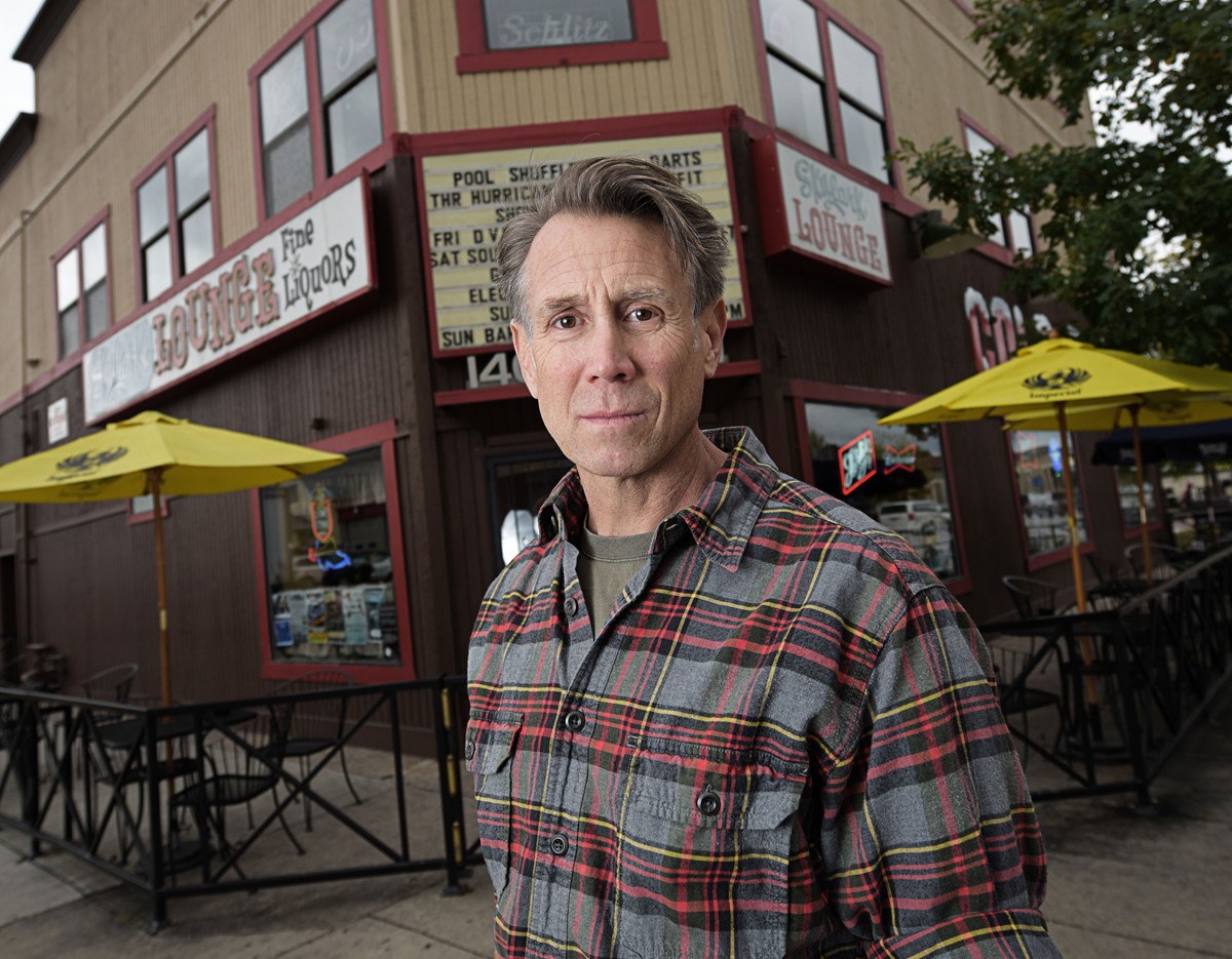
Skylark Lounge owner Scott Heron is pro-bike but sees “huge conflicts” in the city’s pilot program on Broadway.
Anthony Camera
The pilot program was launched in the summer of 2016, with a $100,000 investment in lane striping, signage and signals, and flimsy white poles separating the two-way cyclists from the roaring one-way traffic. (The “protected” aspect comes largely from a buffer of parked cars, shifted outward from the curb.) The lane runs just four blocks, from Bayaud to Virginia, before it evaporates like a drop of sweat on hot asphalt.
A year into the modest experiment, the Broadway bike lane has drawn both praise and derision, with nobody particularly satisfied with the current state of affairs. Supporters say they’re encouraged by the results but want the lane extended several blocks to the north, so that it can provide a useful connection to the Cherry Creek bike path and downtown. Detractors regard the arrangement as confusing, dangerous and misguided.
Studies suggest that well-designed protected lanes can induce commuters to ride bikes who might otherwise pass, fearing injury; such lanes also tend to change the demographics a bit, drawing more female riders. But to be effective, the lanes have to go somewhere. Right now the Broadway lane doesn’t go anywhere, unless you’re looking for a survivable method of crossing Alameda Avenue.
“Having it there is a good start, but most people on the street will tell you that it’s kind of an island,” says Marty Lavine, president of the Baker Broadway Merchants Association. “If they have the funds to finish it, they should get it done.”
“It’s not a section where we knew we were going to generate a whole lot of bicycle traffic,” acknowledges Emily Snyder, Denver’s urban mobility manager. “We chose that section because we wanted to separate bike-turning movements from vehicle-turning movements. It also crosses Alameda, a major point in our signal cycle. If we could keep vehicular traffic moving there, we felt confident we could build it the rest of the way up the traffic stream.”
Bike advocates have been critical of the piecemeal introduction of bike lanes downtown, saying they’d rather have a more coherent, if bare-bones, network than fragmentary dedicated lanes that abruptly end after a few blocks. Bike Denver’s Waddell thinks the city is headed in the right direction but questions its approach to the Broadway project.
“My organization was very invested in this, to get it off the ground,” he says. “But my personal opinion is that the city might have expended too many political and financial tickets on this project. It didn’t make a ton of sense to me; I would have just put white stripes on all the streets when nobody was looking. Let’s get as much of the minimum bike lane on the street as we can.
“If the result is that it gets funded all the way to Speer and the Cherry Creek bike path, then maybe it was a success. We found out a lot of information, but we also gave oxygen to a lot of minority voices that like to complain about everything.”
One source of complaints has been the impact on street parking for Broadway businesses. Snyder says the bike lane initially “had to take more parking than we thought,” but some spaces were restored by shortening turn lanes; in the end, the study area lost 19 spaces out of 98. But Skylark Lounge owner Scott Heron disputes the official figure; he says he walked the area, measuring as he went, and came up with 27 parking spaces sacrificed to the bike lane — metered spaces, for the most part, that could be expected to accommodate numerous customers over the course of a day and evening.
“It’s a big deal when you have a little business and you lose seven spots in front of your place,” says Heron, who lost seven of the nine spaces closest to the Skylark. “It’s a hardship for a lot of the businesses.”
Residential areas on both sides of Broadway now have permitted parking to keep the club crowd from stashing their wheels on side streets, but Lavine says the area still has adequate parking and the complaints are overstated. “If you’re in RiNo or downtown, the odds of parking in front of where you’re going are slim,” he notes. “For whatever reason, that mindset is lost on South Broadway.”“They’re pitting drivers and bikes against each other instead of solving problems.”
tweet this
Snyder says that parking and loading zones are a “shared resource” that have to serve many competing needs and businesses. “It used to be that we could take more personal ownership of the street space,” she says. “Some of the business owners weren’t excited about the loss of parking, but the employees were excited — because now they were getting to their job by bike.”
Some business owners regard the bike lane as a welcome first step in creating a “Main Street” atmosphere for South Broadway. “You’re going to lose some parking spaces when you do that kind of infrastructure, but you can start bringing people down here who don’t need to park,” says Chia Basinger, co-owner of Sweet Action Ice Cream, located north of the study area. “The status quo we’ve had, it’s more of a highway for commuters than a street that encourages shopping. We want people to be able to access our neighborhood. I think this is one of the ways to do it.”
Last spring the city released a preliminary evaluation of the bike lane covering its first three months of operation. Its central finding was that, although auto traffic had been reduced from four lanes to three, congestion had been barely affected at all; the average travel time on Broadway from Colfax to I-25 had increased all of nine seconds, confirming planners’ assertion that the street has sufficient capacity to accommodate bikes as well as cars. The analysis also indicated that very little traffic was diverting to other streets, and that the percentage of women bicyclists on that stretch of Broadway had doubled.
Online surveys suggested that many area residents regarded the program as a success and wanted to see the lane extended to downtown. The response among business owners and motorists was much more divided between cautious approval and loathing. One of the goals of the project had been to deter cyclists from riding on the sidewalk, where they pose a hazard to pedestrians, but 28 percent of the riders still opted for the sidewalk rather than the bike lane, possibly because they found a four-block shift to the street to be inconvenient or didn’t regard the poles as much protection at all.
“There are still a lot of people riding on the sidewalk,” says Heron. “I’m a pro-bike guy, a total environmentalist, but I would not use that bike lane. They put two-way bike traffic on this busy one-way thoroughfare. If you’re driving south and want to turn left, you have someone coming over your left shoulder who has the right of way.
They present it as being safer, but every single intersection has these huge conflicts.”
Heron believes the city would have been better off establishing a dedicated bike lane on Bannock, away from the madding crowd. Snyder says the signage and separate traffic signals for cars and bikes are designed to clear up any confusion. The early data indicates that the number of traffic accidents in the study area was reduced by two-thirds over the same period the previous year; Heron is skeptical of the safety claims, describing one bike-auto conflict that occurred outside the Skylark and left the cyclist shaking and his bike dragged under a car. A better picture of the program’s benefits and flaws is expected to emerge in a one-year report to be released this fall.
The general obligation bond package on next month’s ballot includes a $12 million injection of “multi-modal improvements” along the Broadway corridor, from the light-rail station at I-25 to Sixth Avenue. That includes not only extending the bike lane north, but also beefing up transit. A few weeks ago, the city designated one lane on Broadway and Lincoln for buses only at all times; previously, cars had been allowed to use the lane outside of peak periods. The idea, Snyder explains, is to increase the efficiency of transit in the corridor, providing another way in and out of downtown, since the light rail from South Broadway is already operating near capacity at peak times.
The net effect for drivers heading south on Broadway is, of course, the loss of yet another lane they’d been accustomed to regarding as part of “their” space. Snyder and others will be watching closely to see how commuters respond to this affront. According to the three-month evaluation, the addition of the bike lane led to only a slight increase in the number of drivers sneaking into the bus lane when they weren’t supposed to — a total of about 120 an hour, or two per minute. But the added pressure of losing another lane could well boost the rate of non-compliance. Just as scofflaw cyclists prefer the sidewalk to the terrors of the street, scofflaw motorists could prefer the bus lane to the jam in the center of the street, or ditch Broadway altogether.
“People perceive that we’re looking out for the bicyclist or the bus rider,” Snyder says. “But we are also looking out for the people in cars. We’re trying to anticipate what is coming, and they’re reacting to the now. If we continue to travel in single-occupancy vehicles, people are going to be stuck. It will be painful in five years if we did nothing, and you’d have no option.”
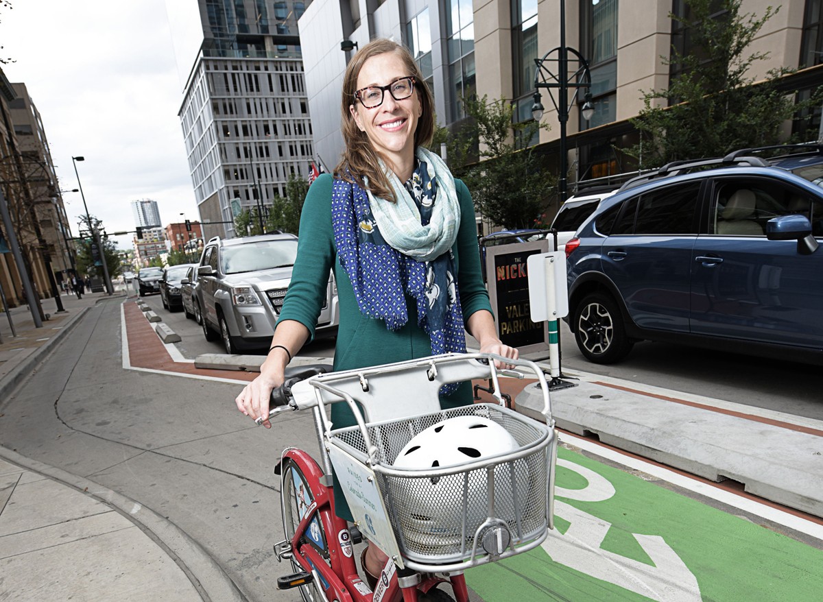
Emily Snyder, Denver’s urban mobility manager, says the bike lane on South Broadway has had a minimal effect on auto travel times.
Anthony Camera
Locantore, the executive director of the Colfax Avenue Business Improvement District, took some pictures of the gathering. As he saw it, the scene was a vivid demonstration of the chief problem with transit on Colfax: There’s nothing rapid about it. “The buses get held up by traffic,” he says. “But if you have a dedicated lane, that doesn’t happen.”
For most of the first part of the twentieth century, before the personal automobile became the centerpiece of transportation planning in most American cities, Denver had a thriving streetcar system. At its peak, it operated more than 250 cars on 160 miles of track; but after World War II, competition from buses and cars made the system obsolete. The last remnant of the line now operates as the Platte River Trolley, shuttling passengers along 1.2 miles of track between REI and Sports Authority Field.
For several years, some transit enthusiasts have pushed the idea of a streetcar on East Colfax. Skeptics like the Independence Institute’s O’Toole denounced the notion as insanely expensive and impractical; such a move would take out lanes of auto traffic for a technology that, whatever its value as a nostalgic artifact or a tourist draw, is relatively pokey and carries few people. But backers persisted, a federal grant was obtained, and in 2010 city planners embarked on an exhaustive “alternatives analysis,” studying various options for increasing travel capacity on East Colfax between I-25 and I-225.
The ten-mile corridor already has the heaviest bus ridership in the network, with total traffic volume exceeding capacity in peak hours — and projected to increase by 20 to 30 percent in the next decade or so. With no politically viable way to expand the existing road footprint, the planners considered several exotic means of moving more bodies through Denver’s most storied and snarled street. They looked at magnetic levitation trains with a construction cost of more than $100 million per mile — a hit in Shanghai, but nowhere else. They looked at monorails (up to $80 million per mile), although one hasn’t been attempted in the United States since the latest Vegas Strip train debuted in 2004. They ran the numbers on light rail ($40 million to $80 million per mile, depending on amenities), modern streetcars ($30-60 million), personal rapid transit ($20-$60 million) and gondolas ($10-$50 million).
They did not consider hot-air balloons, teleporters or time machines.
A 2015 draft study concluded that the most cost-effective, efficient and suitable mode of transportation for the corridor would be some form of bus rapid transit (BRT). Modern, low-floor buses traveling in their own dedicated lanes — at peak times, if not all the time — would be liberated from the auto traffic and able to cover the routes with greater frequency and carry more people. Fares would be purchased at kiosks ahead of time, speeding up the boarding process. Knowing that they had to wait only three minutes for the next bus would lure commuters to transit who’d always shunned the lumbering, often-tardy 15. And the entire system could be built for a tenth of what a streetcar would cost.
The Colfax Business Improvement District hasn’t taken a position on the proposed BRT, but Locantore says many business owners in the corridor are intrigued by the prospect — and hoping the long-term benefits will outweigh construction impacts in the short run. Much of the current commuter traffic on Colfax consists of “pass-through” motorists on their way to somewhere else; an influx of bus riders might patronize more local shops and restaurants. A similar BRT system in Cleveland has received mostly positive reviews from the business community.
“The congestion isn’t going to get better, no matter what path we take,” Locantore says. “But how can we manage it best? It’s going to be less about moving cars and more about moving people. Any well-functioning bus system can carry more people. The smart businesses are going to be catering to the people riding the bus.”
Still, there are many unknowns regarding the proposed system. It’s a venture largely conceived and developed by the Hancock administration, not the Regional Transportation District — the city’s first major venture into transit operations. RTD would be reduced to the role of providing buses for a service that would mainly benefit Denver residents, who’d also be providing most of the funding.
“The city has never been involved in building transit before,” notes Ryan Billings, Denver’s BRT project manager. “But we’ve recognized over the last couple of years that the city does have a role in transit planning.”
Denver has one of the highest rates of commuters in single-occupancy vehicles in the country.
Westword
“Seattle is the only major urban area in the country where transit’s share is increasing,” says O’Toole. “And they spent billions to accomplish that.”
Author of The Vanishing Automobile and Other Urban Myths, O’Toole has advanced a number of arguments over the years challenging transit advocates’ assertions that buses and trains have decided economic and environmental advantages over cars. By his calculations, buses and trains consume more energy and spew more pollution per passenger mile than the average car — and, even when highway subsidies are taken into account, cost far more to operate. But even O’Toole professes to be a fan of BRT. He recently wrote an appreciation of the Flatiron Flyer, RTD’s wildly popular Boulder-Denver bus that shares an express lane with high-occupancy vehicles and single drivers willing to pay a toll.
“BRT can do better than rail, but I’m opposed to dedicated lanes, and I’m opposed to a lot of new infrastructure for transit,” he says. “Simply stopping fewer times and having you pay before you board the system is going to account for most of the gains [in ridership].”
Next month, voters will be asked to approve $55 million to build the East Colfax BRT, as well as $20 million in streetscape improvements along the entire Colfax corridor, as part of the general obligation bond. But it’s not clear what they’re buying at this point. Project manager Billings says the city is still reviewing design alternatives, such as whether the BRT lanes should be aligned on the far sides of the street or down the center.
(The latter seems to be gaining favor.) It’s unknown how many parking spaces will be lost or what the final design will look like. The original wish list for the project, including various station amenities, reached a total of $145 million; that figure was trimmed by almost two-thirds by the time it was folded into the bond package. Fanganello calls the $55 million price tag “a pretty conservative estimate” for a stripped-down system and suggests the actual cost might be discerned further in the design process.
Even less known is the degree to which BRT would boost transit use in the corridor. The MAP predicts that the number of daily bus riders on Colfax will double, from around 22,000 now to 44,000 in 2035. O’Toole is dubious that the system will gain enough riders to justify the loss of two lanes of auto traffic.
“The BRT lines I’ve seen have increased ridership by 30 to 50 percent,” he says. “That’s more realistic. And you can get that without dedicated lanes.”
“Doubling of ridership is pretty massive,” Billings acknowledges. “There’s a caveat here — we don’t know of one [system] that has doubled ridership, but we’re looking at 2035. We’re pretty wary of that number. But if we were to make this really awesome, we believe people will flock to this.”“If we were to make this really awesome, we believe people will flock to this.”
tweet this
The city’s studies predict that placing bus rapid transit on Colfax will have a minimal impact on congestion and travel times, increasing a driver’s journey through the entire ten-mile stretch by four minutes or so. That, also, seems like a head-scratcher, since the street would be losing a lane of auto traffic in each direction to accommodate the BRT. Given that Colfax is already operating above capacity much of the day, how can one lane function as well as two?
The answer is simple. The planners anticipate that many drivers — not all, but many — will avoid Colfax or turn into bus riders. Overload problem solved.
“When you reduce vehicular capacity of Colfax by 30 or 40 percent, where does it go? About a third of that goes a completely different route,” Billings says. “Another third switches to riding the bus. The last third diverts to parallel routes, such as 13th and 14th avenues. Our analysis found that there is capacity on those streets, and they can mostly handle it. Where they can’t, we can mitigate that.”
If the bond issue passes, Billings and the rest of the mayor’s transportation team will be able to take their plans for mitigation and prodding people out of their cars to the next level. Whether they will win the hearts and minds of the people inside the single-occupancy vehicles that make up most of the traffic on the road is an open question. Even some supporters of the MAP are troubled by the mixed messages the city is sending out. For example, at the same time that the mayor is vowing to reduce greenhouse gas emissions, the city has partnered with the Colorado Department of Transportation in its controversial expansion of I-70 through northeast Denver, a $1.8 billion project that has drawn lawsuits over environmental concerns and other protests.
Waddell of Bike Denver says the kind of cultural change the city is seeking requires a substantial investment in making alternatives to the auto convenient and affordable. “At the end of the day, the budget says who you are, what kind of a city you are, what you prioritize,” he says. “It takes political will to do that. I don’t know if we see a ton of it here. There’s definitely going to be some teething problems. But in the grander scheme of things, I think they’re on the right track.”
Fanganello agrees that the job ahead requires more than just a few new stripes and lane alignments. “The way we’ve talked about transportation historically has been, ‘How do I get from here to there?’ But it’s really much more complex than that, in terms of the quality of life what we want to have, the safety we need, the type of place that we’re building, and the cost.”
But before the mobility plan can go anywhere, the bond issue first has to go to the voters. Their decision will go a long way toward determining whether it’s possible, in the next decade or two, to get there from here.