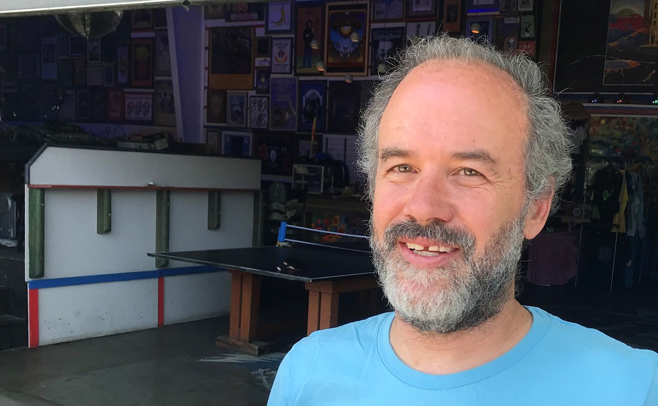
“When you dig out an acre of land, the amount of life you’re destroying is phenomenal,” he says. “Any nook or cranny of soil, somebody’s living there. What they’re talking about doing here would be devastating to a piece of Denver that’s at the heart of Denver. This golf course and the park are jewels.”
Rutter doesn’t play golf. But like many central Denver residents, he has come to view the course as an extension of the park, a public space that provides not only solace for weary urbanites, but habitat for foxes, raccoons and coyotes. He rides his bicycle through the course after dusk, cross-country skis there with a young nephew when there’s enough snow. The lack of nearby light sources makes the interior fairways a great place for star-gazing on a moonless night.
Originally from Illinois, Rutter came to Fort Collins in 1970 to study biology at Colorado State University. He fell in love with the state and, over the past few years, has gotten involved in the occasional bit of grassroots activism, from protesting an ill-fated attempt to install luxury boxes at Red Rocks Amphitheatre to pushing quality-of-life issues in the south City Park neighborhood. But nothing has stirred his sense of civic outrage more than a current piece of city planning that, if implemented, could involve substantial bulldozing of the western third of the golf course and the removal of hundreds of trees.
The modest proposal, known initially as the Two Basin Drainage Project (TBDP) but now being touted as the Platte to Park Hill Stormwater Systems, is intended to help control storm runoff in the northeast part of the city — water that flows north and west from Fairmount Cemetery through the Montclair, Park Hill, Cole and Whittier neighborhoods to Elyria, Swansea, Globeville and ultimately the South Platte River. The $134 million undertaking is being overseen by Denver’s Department of Public Works, with some financial and technical assistance from the Colorado Department of Transportation and the Urban Drainage and Flood Control District.
Although many details of the project are still officially “under study” and have not been finalized, certain basic features have been presented in public meetings in recent months — and have raised hackles among neighborhood groups. One essential component is an open channel, fifteen blocks long and up to a hundred feet wide, to be dug along East 39th Avenue between Franklin and Steele streets, that would slow down heavy storm runoff headed to the river. Another key piece of infrastructure is a detention “pond,” around thirty acres in size, to be situated either in the Cole neighborhood or on the golf course. The pond would remain dry except in the most extreme storm conditions, yet building it could require demolishing several houses in Cole — an early configuration, since rejected, would have taken out more than forty homes — or removing up to 280 of the 872 trees on the golf course. And that’s just for the first phase of the project, addressing drainage needs in the Montclair Basin; another detention pond is planned for the Park Hill Golf Course as part of drainage improvements for the Park Hill Basin, the second basin in the TBDP.
City officials say the project is urgently needed to fix long-festering drainage problems in some of Denver’s poorest neighborhoods — and curtail hazardous street flooding, such as one event last June 24 after heavy rains in the area. “It is my fervent belief that in this project the city is acting as an advocate for neighborhoods, to deliver the project as fast as we can to provide stormwater relief,” Gretchen Hollrah, the city’s deputy chief financial officer, told one gathering of neighborhood organizations last month.
But Hollrah’s statement was met by guffaws from some of the more skeptical attendees. While there’s no question that Denver’s aging stormwater infrastructure is in bad shape — the city currently has a backlog of $1.5 billion in drainage projects, and less than $30 million in the annual budget to spend on them — plenty of questions have arisen about the TBDP, and the speed and determination with which the city is pursuing the project as a top priority. Several area activists have questioned whether the long-term benefits of the project, which would be chiefly apparent during a hundred-year-storm, outweigh the sizable impacts it will have on the neighborhoods it claims to serve.
Some suspect that the primary beneficiary of the improvements won’t be poor communities but the controversial below-grade I-70 expansion through east Denver planned by CDOT, which is putting up much of the front money for the TBDP drainage work. Not so coincidentally, the project also offers needed flood relief for industrial areas flanking the highway targeted for future development, as well as for one of Mayor Michael Hancock’s legacy projects: a billion-dollar makeover of the current National Western Complex, which sits at a low point of the Montclair Basin drainage area.
While planners have promised that the TBDP final design will be achieved through a “robust public process,” critics say that so far the process has amounted to a frustrating series of PowerPoint presentations and few specifics. Rutter has gone to several of the meetings, chatted up city engineers after the formal spiel, pored over documents, and concluded that, whatever the merits of the project, it’s being sold with exaggerated claims of averting disaster and misleading pictures of swamped cars. “I think it’s been highly deceptive,” says Rutter. “They come to these meetings and mislead people into thinking that this is going to do something for them.”
The communities downstream from the drainage improvements, the Globeville-Elyria-Swansea area, would seem to benefit the most from the TBDP. But several residents and business leaders there say they, too, have deep reservations about the project, which would significantly alter Globeville Landing Park in order to expand the outfall to the river. “They went ahead and made all the major decisions without any public input whatsoever,” says Drew Dutcher, president of the Elyria and Swansea Neighborhood Association. “And then they come to us and say, ‘Oh, do you like this?’”“There are a few people who just don’t want us to do anything, and we hear from them every day.”
tweet this
Jamie Price, program director for the entire project, notes that his team has held dozens of public meetings in the past few months to explain the stormwater issue and gather citizen comments. “We get a lot of positive feedback, that this makes total sense,” he says. “There are a few people who just don’t want us to do anything, and we hear from them every day. But that doesn’t mean they represent a consensus.”
Still, the two options for detention currently on the table have generated a host of objections from City Park Friends and Neighbors, Denver Inter-Neighborhood Cooperation, and more neighborhood groups in Cole, Clayton and other affected areas. Virtually all of the groups want to see other alternatives that don’t involve radical surgery in the Cole neighborhood or on the golf course. The rationale behind the TBDP has also been lambasted by former city councilwoman Susan Barnes-Gelt, a frequent critic of the Hancock administration.
“This is an engineer’s wet dream,” Barnes-Gelt declares. “The City of Denver gets fifteen inches of precipitation a year. To me, that’s the starting point. This is a 500-year flood solution in search of a problem.”
TBDP project manager Jennifer Hillhouse says her team “spent several months pushing the envelope” in search of the best solutions to a very real flooding threat. “We’ve looked at a range of alternatives,” she insists. “But the two that rose to the top are the two that are in front of the public right now. It is a really great project, and it’s really needed.”
Cole resident Kim Morse first found out about the big stormwater project last November, when she attended a public meeting at the Bruce Randolph School on Steele Street. There were far more city employees than residents in attendance, which may be why few people seemed to share Morse’s astonishment when she realized that the plan being unveiled presented several different ways of inserting a three-block retention pond into her neighborhood. One drawing showed the pond taking out a solid block and a half of homes in what has become one of Denver’s most affordable, vibrant communities.
Morse found it curious that the city’s outreach effort, which involved a host of consultants and public-relations professionals hired to conduct meetings, hadn’t drummed up more of a crowd. “They told me they fliered the neighborhood,” she recalls. “It’s like something you do when a new pizza shop comes to town. You would think they would do a lot more to let people know about something this important.”
The belated public-engagement process, just months before construction is scheduled to begin, has prompted neighborhood leaders to ask what’s the rush — and, more to the point, who’s driving the bus. City planners say the project has been under discussion for years, yet it failed to receive any mention in the highly detailed 2014 version of the city’s storm-drainage master plan, a planning document that’s updated every five years. The real push for the Two Basin Drainage Project seems to have come from low-profile discussions among a group of planners and engineers puzzling over the drainage hazards associated with the expansion of I-70 in east Denver.
The group, known as the I-70 PCL Drainage Multi-Agency Technical Team, includes representatives of the city, CDOT, Urban Drainage and the Regional Transportation District. According to one planning memo, the group was formed in late 2013 “to collectively investigate the Montclair basin’s hydrology and other inter-agency coordination issues.” One particular goal was to provide a fresh analysis of the way water flows through the basin “in order to provide CDOT with a mutually agreed upon off-site 100-year design flow rate for the I-70 PCL project.”
PCL stands for Partially Covered Lower Alternative, the preferred option that CDOT is pursuing to replace the crumbling highway viaduct that cuts through the Globeville, Elyria and Swansea neighborhoods. The $1.8 billion plan, which involves taking I-70 below grade and covering four acres of it to restore some degree of “connectivity” to local residents — while at the same time expanding the highway to ten lanes, including toll lanes — has been a subject of intense controversy for years. Among the many engineering challenges of such a project is the puzzle of how to keep the belowground portion from flooding in heavy storms.
Not surprisingly, the TBDP team has been eager to distance its drainage project from the I-70 debate. The two projects are entirely separate, Price insists. “We need to work in alignment and coordination with CDOT and RTD,” he says. “We’re trying to do that in the most responsible way possible. Our project needs to go forward whether they go forward or not. But you could say it’s a rising tide that’s raising all boats.”
CDOT officials say that they have their own plans for on-site detention ponds and other drainage for the highway and that the city’s project merely adds an extra layer of protection. “If there’s less street flow that’s coming toward the highway, then that’s less water we have to capture,” says CDOT spokeswoman Rebecca White.
“When you do have debris in flood-storm situations, redundancy is a wonderful thing for engineers,” I-70 East project director Tony DeVito told Denver City Council members last summer.
Yet the two projects are more deeply intertwined than either side seems willing to acknowledge. DeVito’s remarks came as the council was preparing to approve an intergovernmental agreement (IGA) between the city and CDOT that requires the state to pay for 40 percent of the city’s stormwater project, a commitment of between $40 million and $60 million. In return for providing substantial funding for the city’s project — described by DeVito in one memo as “key elements of the drainage system needed for I-70 East” — CDOT will receive a few concessions of its own. The city will kick in $37 million toward highway costs, spread out in installments over thirty years, as well as another $46 million in “in-kind” contributions, including waivers of permit fees and taking over maintenance costs of portions of Brighton Boulevard. The city also agreed to pay CDOT $5,000 a day in damages if it failed to meet certain deadlines for completing its drainage improvements.
Approving the IGA was one of the last bits of business concluded by a lame-duck council before most of its members ended their term, just days before a group of newbies who’ve been critical of the city’s frenzied growth took office. The timing struck some of the highway opponents as suspicious. But at that point, nobody was paying too much attention to a map attached to the agreement, which designated a substantial shaded area of the Cole neighborhood as “TBDP Detention Pond/Open Space.”
After learning of the proposed detention area at the meeting last November, Morse began knocking on the doors of people who’d lived in Cole much longer than she had. None of them had heard of the plan. She studied maps prepared by the planners, which showed that the areas that would most benefit from the TBDP were in the industrial zone north of the channel on East 39th Avenue — including the National Western Center and I-70. One of the photos the planners had used to illustrate the flooding problem showed a swamped car at 36th and High — but that was upstream of the proposed detention pond, which didn’t actually provide any flood protection for Cole that Morse could see. (Other photos of flooding used in the TBDP presentations were taken at 33rd and Olive and 14th and Kearney; the proposed detention pond for the Park Hill Basin wouldn’t help those areas, either.)
“The city has been selling this in a way that is very misrepresentative,” Morse says. “The flooding occurs south of where they want to do the detention.”
With Morse and others sounding the alarm, a subsequent Cole neighborhood meeting about the stormwater project brought a packed house — and many irate questions. The planners soon backed off the option that would have taken out a block and a half of houses and began talking about possibly locating the detention pond on the golf course instead. Putting it there would provide some flood relief for neighborhoods downstream; Price says that configuration could reduce flooding in Cole by 50 percent during small storms, less during larger ones. But both he and project manager Hillhouse stress that the TBDP is only the first phase of the drainage fixes needed in the Montclair and Park Hill basins.
“It does provide a backbone,” Hillhouse says. “Without this project, you would never be able to realize long-term benefit and begin to solve the need.”
In addition to the golf-course site, the planning team is still considering three possible locations for a detention pond in Cole. To Morse, that suggests that the project’s real goal is to protect industrial and developable land to the north, and possibly to lay the groundwork for Cole itself to undergo some form of transformation as the city pushes for transit-oriented development along the soon-to-open RTD commuter rail line winding from Union Station to 38th and Blake and on to Denver International Airport — an area that Mayor Hancock has designated as the city’s “corridor of opportunity.”
“The city knows that years of development have created this problem because there isn’t enough permeable space,” Morse says. “If they’re so interested in trying to preserve neighborhoods, why are they allowing zoning for things to be built from property line to property line? They want an established, historic neighborhood to take the burden for all the newer development.”
Almost ten square miles in area, the Montclair Basin is Denver’s largest urbanized watershed. It’s also the largest basin in the city that doesn’t have some form of surface drainageway. A hundred and fifty years ago, two streams converged at what is now Colfax and Colorado Boulevard and headed northwest toward the river, but that waterway was paved over long ago.
Storm runoff still flows in the same direction today, but it flows underground. During heavy rains, when the storm drains are blocked or overwhelmed, it flows through the streets, sometimes stalling out cars or flooding basements. Just how frequent or widespread such events are, what kind of threat they pose to life and property, and what to do about them turn out to be complicated questions, with no snap answers.
The words “catastrophic” and “disaster” got passed around like mixed nuts during last summer’s city council discussions about funding the Montclair drainage improvements. The 2013 floods in Boulder County were still fresh in mind, and the rampant street flooding from a heavy-duty storm last June was even fresher. Several of the project’s backers reminded councilmembers that they had a duty to keep their constituents above water. Paul Hindman, the executive director of the Urban Drainage and Flood Control District, even used the K-word, as if Denver were New Orleans and it was high time to start throwing sandbags on the levees.
Referring to a storm in Aurora at the time of the Boulder floods, Hindman told the council, “If that rain cloud had centered over this basin, you would have had worse damage than you saw in Boulder. And you probably would have seen damage on news clips that would have looked like Katrina, actually.”
“People might think it’s a lot of money for channeling water,” Councilman Paul Lopez observed. “But it would be a disaster if we don’t put this money into the drainage improvements. We’d be looking at billions in terms of loss.”
The threat was so dire, the backers contended, that nothing short of protection from a hundred-year storm would do. (The “hundred-year” label doesn’t mean that weather is reliably cyclical; it simply refers to an event so rare that it has a 1 percent probability of occurring in any given year.) Some critics of the TBDP say that high standard is overkill, since most of the stormwater planning elsewhere in the city aims to handle a five-year storm. But if so, it’s a convenient bit of overkill, given the city’s partners in the project; by federal law, CDOT is required to plan for a hundred-year level of protection in the highway expansion.
Adrian Brown, a civil engineer who specializes in hydrologic issues, notes that while Denver storms can be intense, any flooding tends to be of very short duration. He quips, only partly in jest, that a cheaper alternative to the city’s plan is what he calls the “latte solution”: Go and keep dry in a Starbucks, have a latte, and wait out the street flooding, which will be over in a matter of minutes or hours.
“There’s a very real question as to whether it’s worth our money as a community to keep everybody high and dry and every road and pedestrian walkway and bike path operable at all times, no matter what the hell’s happening with the precipitation,” Brown says. “You just can’t do it. And it is clearly unwise and expensive to try.”
Brown says he’s asked city engineers if preparing for a once-in-a-century event is a “reasonable planning horizon.” The answer varies. “How much you should plan for is really a social issue,” he explains. “As you up the protection level, the cost skyrockets. Most municipalities have come to the conclusion that having major impact from flooding every year is too much; every five years — we can live with that.”“This is an engineer’s wet dream.... This is a 500-year flood solution in search of a problem.”
tweet this
The city’s own modeling of what the Montclair Basin would look like in a hundred-year flood shows almost no areas in the entire basin where the water would rise more than three feet, and in most places the runoff would be considerably lower than that; the areas that would be most impacted are Ferril Lake and the duck pond in City Park, as well as a low section of the golf course — all of which are already serving as designated detention areas for the basin. Yes, people can drown in three feet of water — city officials are quick to bring up the 2000 death of a Denver firefighter who was trying to rescue a woman during a flash flood — but a few pockets of short-term, knee-level street flooding don’t represent a Katrina-like apocalypse.
Price says the depth of the water isn’t the only factor to consider; there’s also the velocity. A hundred-year storm would bring runoff with twice the force of the South Platte’s normal flow, coursing through the basin and getting funneled into a narrower channel as it approaches the river. “We had a fifty-year event in Boulder in 2013, and you saw what that did,” he says. “A hundred-year event in Colorado can be extremely destructive.”
In a truly catastrophic scenario, such as the 1965 South Platte flood, a little extra drainage infrastructure wouldn’t make much difference — unless it was something on the scale of Chatfield Dam, which was built in response to the ’65 deluge. But that doesn’t mean that modest improvements, focused on particular trouble spots, wouldn’t help areas that now have inadequate drainage. Brian Hyde, a retired hydrologist for the Colorado Water Conservation Board and a Park Hill resident, says there are several streets in the Montclair and Park Hill basins that have proven hazardous during severe storms. “We don’t know what the worst is that can happen,” says Hyde, who writes a column about water issues in the Greater Park Hill News. “The language of a hundred-year-flood misleads people when you’re actually talking about annual probabilities of risk that we don’t control.”
But Hyde also seconds Brown’s fundamental point: Whether hundred-year-flood protection is a wise investment or not, most of the communities in the Montclair Basin won’t see any additional flood protection from this particular project. “For my neighborhood, for where I go shopping, for many places in the Montclair Basin floodplain, it doesn’t do anything,” Hyde says. “Everything they’re trying to do is to get the water to make a left-hand turn somewhere before I-70. You’re taking the historic drainage process and cutting it off to protect I-70.”
The purpose of detention ponds is to slow down the volume of water headed to the river; the areas fill up only in the heaviest storms, and then the water recedes in a matter of hours. A decade ago the city retooled Ferril Lake so that it could hold additional stormwater runoff. In 2014 the Department of Parks and Recreation entered into an agreement with Public Works that recognizes that the park’s duck pond and a section of the golf course as it now stands serve as “inadvertent detention” as well. Rutter believes the city could minimize the impact new retention areas would have by increasing the size of the existing detention at the duck pond and the golf course, which currently provide nearly eighty acre-feet of water storage. “I just think there have to be better ways to do this that don’t involve destroying the golf course,” he says.
But Price doubts those areas alone can provide the additional 100 or 140 acre-feet of detention the project requires. “We could probably create some additional detention in those locations,” he says. “I think we’ve looked at those, and in terms of cost-benefit, they may not be the right places to go. The options are really limited. If you look at the area north of City Park, out to the railroad, there just aren’t a lot of city assets. There are a lot of homes and businesses, but not a lot of city assets to address this volume of flow.”“They want an established, historic neighborhood to take the burden for all the newer development.”
tweet this
Many of the alternatives that residents have proposed, such as establishing a series of smaller retention areas across the basin, just aren’t cost-effective, Hillhouse adds. “The more you divide it up, the bigger the footprint,” she says. “There just aren’t as many efficiencies.”
Both managers say the project’s cost, initially pegged at $134 million, may turn out to be higher; an updated figure won’t be available until after the team has settled on a preferred alternative and embarked on preliminary design. But whatever the cost, they expect to be seeking a stormwater fee increase from city council next month. The fee has only been raised twice in the last two decades, and the anticipated increase will go toward not only the TBDP, but other drainage projects across the city. Because it’s a fee hike, not a tax, it doesn’t require voter approval under the TABOR Amendment.
That the city is embarking on such a massive project without any kind of formal public buy-in astounds former councilwoman Barnes-Gelt: “To take the golf course and turn it into a swamp, and demolish the clubhouse, and change the whole course — are you kidding me?” she asks. “It’s just bizarre. If they think this is such a good idea, they should go to the voters.”
At a community meeting three months ago, Dave Oletski got his first glimpse of what the city has in mind for Globeville Landing Park, a small patch of greenery on the east side of the South Platte, surrounded by a heavily trafficked industrial zone. A storm-drainage channel slips under the park and empties into the river; the stormwater project calls for that channel, the critical Globeville Outfall, to be greatly widened and improved, creating a wetlands area in the middle of the park.
To Oletski, president of a Globeville neighborhood group, the concept diagrams didn’t seem to leave much room for the park. “There was going to be no lawn,” he says. “It would be a big swamp.”
Tucked behind a Pepsi plant, the current park isn’t exactly a major draw. Aside from a disc-golf course, a shelter and a smattering of graffiti, the amenities are scarce. But it’s a welcome rest stop for riders biking along the river, and in last year’s campaign to persuade voters to back the National Western Center expansion, there was much talk of turning the park into a kind of riverfront gateway to the splendors of a “dynamic year-round tourist destination.” Oletski doesn’t care much for the plan to turn park land into drainage, and even less for the fact that the neighbors seem to have been consulted about the move as an afterthought.
“My grandma always called this place the Bottoms,” he says. “Yeah, the water has to come this way, whether we want it to or not. It has to go to the river. But we don’t want to bear the brunt of this project. This is an up-and-coming neighborhood, and that park is going to be well used.”
RiNo developer Mickey Zeppelin, who attended the meeting with Oletski, had a similar reaction. “We were all shocked that they hadn’t disclosed that they were going to take the park apart to put in the drainage,” he says. “They claim it will be better, but why didn’t somebody ask people in Globeville what they thought about it? In major floods, the neighborhood will benefit, ultimately. But I have a problem with the manner in which this thing is being done — the whole process, without any information or input.”
Hillhouse says that Globeville Landing will be redeveloped into something bigger and better than what is there now; while the site will be losing some land to the new channel, more land will be added. The city is still gathering “public input” on what sort of features the community might want in the new park, such as a playground.
Various amenities have been offered in connection with other components of the project, too, in an effort to make the TBDP seem more like a bonanza for neighborhoods than an intrusion. The fifteen-block open channel on 39th Avenue will be accompanied by bike paths and pedestrian trails, similar to an existing channel in Harvard Gulch Park. Regrading the golf course would require closing the facility for more than a year and quite possibly taking out more than a fourth of its trees, but it’s also an opportunity to move the clubhouse to higher ground and add roughs and hazards to make the course more challenging. And, of course, the construction crews would do their best to save the big cottonwoods on the perimeter of the course and plant new trees to replace those in the way of the project.
But Rutter, Barnes-Gelt and other critics of the drainage project don’t find such promises reassuring. A few pieces of playground equipment can’t disguise the fact that the project involves a significant appropriation of open space — what Price calls “city assets” but residents call “parks” — for other purposes. P ark advocates have already had several battles with the Hancock administration over what they consider poor stewardship, going back to a 2012 land swap that turned over nine acres of a formerly designated natural area adjacent to Hentzell Park to Denver Public Schools in exchange for a building near downtown. “The city is in the habit of usurping public space — the public, civic realm — starting with Hentzell Park,” says Barnes-Gelt.
Groups have fought bitterly against subsequent efforts to install a “regional attraction” known as City Loop in City Park, a gasification plant to incinerate animal waste at the Denver Zoo, and the use of high-sodium recycled water in the parks, which is being blamed for an alarming loss of mature conifers in Washington Park and elsewhere. Treating the golf course as a cheap solution for a public-works project looms as the greatest affront yet.
“This isn’t an average piece of city property,” Rutter notes. “This place is a major investment by generations of the citizens of Denver, and its value just increases as space becomes more limited. You’d think the city would recognize that. I think the public is going to have to help them see it for what it is.”
E-mail the author at [email protected].