Fox 31 meteorologist Matt Makens had a great stat on this: It's been over two years since Denver last recorded more snow than average in a month. That's 25 straight months with below-average snowfall in Denver, and unless we see something big these final few days of January, that number will probably bump up to 26.
Everyone around the Front Range — from Colorado to Kansas, New Mexico and Wyoming — has been dumped on by above-average snow so far this winter, but the Front Range itself has been locked in a strange snow hole that's been mainly caused by storm patterns just missing us. In other words: sheer dumb luck.
You've probably also heard the El Niño buzzword thrown around a few times (thanks, Chris Farley). In general, El Niño amps up the subtropical jet stream, a ribbon of fast-moving winds that bring in Pacific moisture, and it tends to travel through the southern third of the country during our winter months.
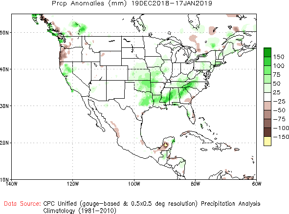
That jet stream tends to get amplified during El Niño winters, bringing in more moisture to places like California and Colorado's southern mountains. El Niño has pretty much behaved according to plan so far this winter. Take a look at this map, which shows above-average moisture for much of the southern third of the U.S. over the past month (shown in green):

Above-average precipitation has been noted across the southern U.S., which is likely the result of El Nino-related conditions.
NOAA
In addition to the active southern jet stream, there are strong signals of a breakdown of the so-called polar vortex, a lobe of cold air that usually stays locked near the Arctic Circle but periodically moves south, bringing with it bitterly cold temperatures. It's looking more likely that a piece of the polar vortex will break off and move south into the eastern half of the country in the next few weeks. So what does that mean for us? Denver and eastern Colorado are often on the fringe of the cold; we tend to get some of it, but not all of it. But even a cooler-than-average stretch for us can bring in enough cold air to supply a significant snowstorm, especially if the El Niño-charged southern jet stream continues to be on steroids like it's been the last few months.
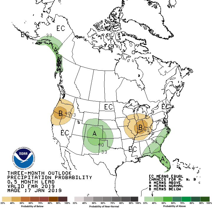
The Climate Prediction Center's February, March and April outlook indicates that we could be due for a big spring, with Colorado as a whole and the Front Range in particular smack dab in the middle of its expected above-average precipitation outlook.

The long-range outlook looks wetter for Colorado. Will that mean snow for us?
Climate Prediction Center
The final clue that we could be in for a solid spring is that the above-average moisture and colder weather coincide with what is typically our snowiest stretch of the year. Fun fact: Denver's three snowiest months of the year on average (listed in order) are March, April and February. A wetter and perhaps colder outlook just in time for late winter and early spring could mean Denver will hit it big.
Does this all mean we're for sure in for a snowy spring? Absolutely not. Seasonal and long-range forecasting is notoriously difficult and still very much in its infancy. In particular, Colorado is a pretty tough spot to forecast long-range, because we're sort of in an in-between zone for a lot of El Niño- or La Niña-related impacts.
But there are signs that maybe, finally, Denver and the Front Range may get at least some of the snow we've been so sorely lacking over the past few years.


