
Denver7 via YouTube

Audio By Carbonatix
Independent Journalism in Denver Needs You
We need to raise $25,000 by August 9 to support the reporting our community depends on. Reader support keeps us independent and is playing a larger role in funding local journalism and shaping what comes next. If you believe independent local journalism matters, make a contribution today.
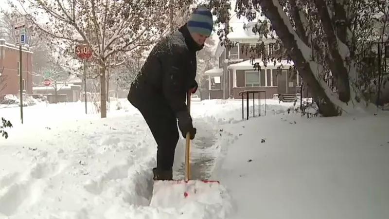
The storm that began hammering Denver on November 25 just in time to screw up Thanksgiving week travel has finally moved on, leaving locals to dig out – and to debate whether they got more snow than their neighbors.
Fortunately, the National Weather Service has the definitive answers. Its map of snowfall reports from the last 24 hours demonstrates how varied the pile-ups were in Denver proper, the greater metro area and beyond. The total for the 55 localities on the list ranges from a low of seven inches to a high of thirty.
I live in the vicinity of Ken Caryl Ranch, and when I woke up around 4 a.m. on November 26, we’d only gotten two or three inches, making me think the snowpocalypse predictions had been overblown, as usual. But the pace of snowfall began picking up shortly thereafter, and by the time the last flake landed, the snow in the assorted driveways I shoveled exceeded sixteen inches – a figure confirmed by the NWS.
How did your neighborhood measure up? Here’s the rundown, which employs National Weather Service directional designations.
55. Northwest Denver – 7 inches
54. South Southeast Denver I – 8.8 inches
53. Lakewood – 9 inches
52. East Denver – 9.5 inches
51. Denver International Airport – 9.5 inches
50 (tie). Northeast Englewood – 10 inches
50 (tie). Brighton – 10 inches
50 (tie). South Southeast Englewood – 10 inches
47 (tie). North Wheat Ridge – 10.3 inches
47 (tie). Northeast Thornton – 10.3 inches
45 (tie). South Southeast Denver II – 10.5 inches
45 (tie). Greenwood Village – 10.5 inches
45 (tie). South Southeast Aurora – 10.5 inches
42. West Southwest Edgewater – 10.8 inches
41 (tie). Denver – 11 inches
41 (tie). East Northeast Denver – 11 inches
41 (tie). East Southeast Lakewood – 11 inches
38. South Denver – 11.1 inches
37. Englewood – 11.3 inches
36 (tie). East Englewood – 11.5 inches
36 (tie). Cherry Hills Village – 11.5 inches
34. West Littleton – 11.8 inches
33. Southeast Edgewater – 11.9 inches
32. Northeast Broomfield – 12 inches
31. South Southeast Buckley Air Force Base – 12.2 inches
30 (tie). Southeast Littleton – 12.5 inches
30 (tie). East Arvada – 12.5 inches
30 (tie). East Northeast Thornton – 12.5 inches
27. West Lone Tree – 12.7 inches
26. North Foxfield – 12.8 inches
25 (tie). West Northwest Highlands Ranch – 13 inches
25 (tie). West Arvada – 13 inches
23. Northwest Northglenn – 13.2 inches
22. Southwest Centennial – 13.5 inches
21. Southwest Highlands Ranch – 13.8 inches
20. North Northeast Foxfield – 14 inches
19. West Northwest Broomfield – 14.5 inches
18. West Wheat Ridge – 15.3 inches
17 (tie). Highlands Ranch – 15.5 inches
17 (tie). Northwest Federal Heights – 15.5 inches
15. West Lakewood – 16 inches
14. West Northwest Arvada – 16.2 inches
13 (tie). East Ken Caryl – 16.3 inches
13 (tie). Southeast Chatfield Reservoir – 16.3 inches
13 (tie). Evergreen – 16.3 inches
10. Southwest Rocky Flats – 19 inches
9. South Southwest Boulder – 20 inches
8. West Louisville – 20.2 inches
7. West Boulder – 20.9 inches
6. Northwest Marshall – 22 inches
5. South Southwest Boulder – 22.2 inches
4. North Aspen Park – 22.9 inches
3. Eldorado Springs – 23.9 inches
2. Northwest Genesee – 27.5 inches
1. South Crescent Village – 30 inches