

Audio By Carbonatix
There’s nothing trickier for governmental agencies, including school districts, than dealing with big winter snows. Those that overreact to weather that fails to live up to advance billing will be blasted by longtime residents who scoff at weather-related panic, while those that respond too slowly to major systems are sure to be accused of endangering lives to save a few bucks.
So messaging about preparations for a storm predicted to slam the state of Colorado in general and the Denver metro area in particular today and tomorrow, February 3 and 4, try to strike a balance between these two extremes. About 24 hours from now, we should know if anyone got it right.
The Colorado Department of Transportation is currently sending up the most warning flags. Its main travel page boasts a “WEATHER ALERT,” updated at 2:08 a.m. February 3, that announces a “Winter Storm Warning from noon Monday to 6 a.m. Tuesday through the I-70 Mountain Corridor. Heavy snow expected. Total snow accumulations of 6 to 12 inches, with the heaviest totals on the eastern slope of the Front Range. Winds gusting as high as 45 mph Monday.”
The announcement continues: “Winter weather is expected through the Central Rockies Monday, bringing snowfall and much-colder temperatures to Colorado through Tuesday. Mountain snowfall begins Monday morning, slowly increasing in coverage and intensity during the afternoon hours. Most mountain passes will see light to moderate snowfall, though the northern/central Divide and east San Juans may see heavier totals. A strong cold front drops down over the foothills and plains tonight, with areas of freezing drizzle possible Monday morning. Snowfall slowly increases during the afternoon and evening, peaking during the overnight period. Areas of heavy snow are possible over the foothills and Palmer Divide, with moderate totals expected for the Denver Metro Area. Lighter accumulations are expected east of Denver and south of the Palmer Divide.”
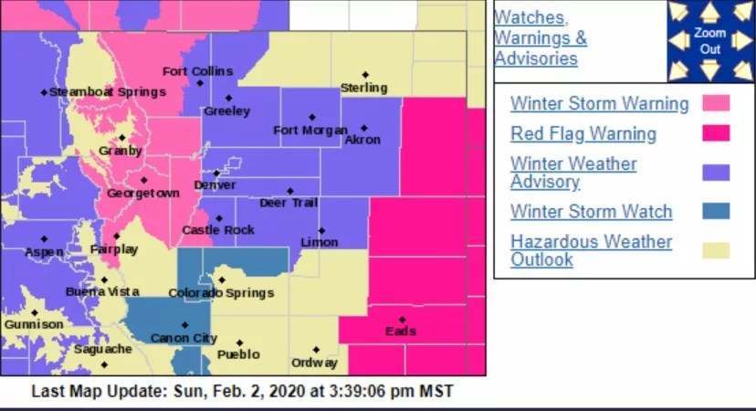
On February 2, Denver’s official Twitter account retweeted this storm map from the National Weather Service’s Boulder branch.
CDOT also sent out an email blast in advance of the February 2 Super Bowl LIV kickoff that began: “Motorists don’t be fooled! 70 degree weather to be met by snow-packed and icy commutes Monday and Tuesday. Potential closures and Chain and Traction Laws likely.” The message stressed that “across the state, where roads and highways are being impacted by accumulating snow, maintenance crews have been assigned to around-the-clock snow shifts beginning Monday morning. All available resources will be utilized. As snowfall rates increase, crews will focus on primary roads and reduce levels of service on secondary roads in an effort to reduce impacts to the main highways. Road closures for safety reasons are possible depending on conditions.”
In Denver, meanwhile, TV stations have been hyping the severity of the system, with CBS4 asserting as early as January 31 that school closures are possible on February 4. But as of this morning, local school districts, which are often targets of rage over such issues no matter what they do, are clearly wary about floating the possibility of a snow day before it’s absolutely necessary. There’s currently no mention of impending dumpage on the Twitter accounts of school districts for Cherry Creek, Littleton, Douglas County, Jefferson County, Five Star Schools (Adams 12), Adams 14, Boulder Valley, Englewood, Westminster and Sheridan.
The same is true of Denver Public Schools, although late on February 2, school board member Tay Anderson posted an update of his own. “As of now ALL Denver schools will be open starting at normal times,” he tweeted before stressing, “The School Board does NOT have influence on calling a snow day. If anything changes I will update you all as soon as I get the information.”
Also silent on storm prospects thus far are the office of Denver Mayor Michael Hancock and Denver Public Works, the agency that oversees plowing; early in December, DPW bowed to public pressure when it de-iced side streets still treacherous from a Thanksgiving week blizzard, even though the department had earlier stated that doing so wouldn’t be effective. Denver’s primary acknowledgment that flakes are on the way can be found on the city’s main Twitter account, which retweeted the map seen above and a note about the winter storm warning from the National Weather Service’s Boulder branch.
If the snowfall is epic, expect social media commentators to fault Denver for taking a low-key approach – but these folks are unlikely to shower officials with credit should their restraint prove wise. That’s the definition of a lose-lose situation.