
National Weather Service

Audio By Carbonatix
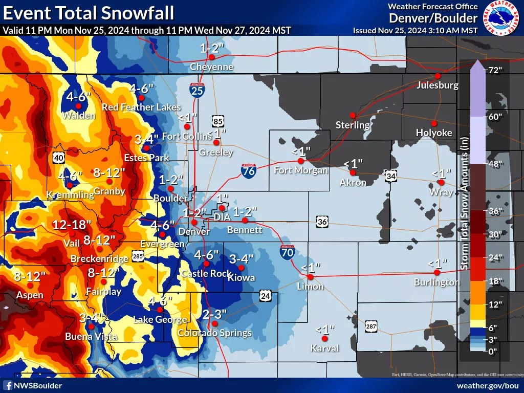
According to the National Weather Service, a major winter storm is about to sweep into Colorado.
Much of the western third of the state is under a Winter Storm Warning starting at 3 a.m. on Tuesday, November 26, and lasting until 11 p.m. the following day, with Interstate 70 and highways 40, 285 and 34 all projected to see weather impacts from snowfall.
“A significant winter storm will impact the mountains and high valleys late Monday night through late Wednesday evening, potentially affecting holiday travel,” the NWS says. “Significant travel disruptions and road closures can be expected. Storm total accumulations of 10 to 20 inches will be widespread for areas within the Winter Storm Warning.”
In Denver, up to three inches could fall, according to some forecasts, with Denver International Airport projected for around two inches, potentially impacting some flights.
On Interstate 70, Vail Pass could see 15 to 24 inches of snow and the Eisenhower Tunnel could get even more, with predictions of 18 to 27 inches. Denver’s ski area, Winter Park, is predicted to see 15 to 23 inches of snow – providing prime powder for those who can make it up the mountain.
But the NWS urges people not to try too hard to travel before Thanksgiving.
“If you must travel, keep an extra flashlight, food, and water in your vehicle in case of an emergency,” the NWS cautions “The latest road conditions for Colorado can be obtained by calling 511 or by going to www.cotrip.org.”
A major winter storm will impact the mountains beginning late tonight. Snow will be heavy through Tue night, lighter Wed.
1-2 ft totals are expected for the highest elevations. Expect significant travel disruptions and road closures. Here's a forecast for major roadways 👇 #COwx pic.twitter.com/LciRjAcp3l
— NWS Boulder (@NWSBoulder) November 25, 2024
According to the Colorado Department of Transportation, many roads could be closed, and the state has issued a travel alert for the mountains
“While the sheer volume of snow will contribute to the majority of impacts, stronger winds will also support areas of blowing snow and reduced visibility, especially over the passes in the Central and Southern Mountains Tuesday and Tuesday night,” CDOT says. “Ski and holiday travelers should expect difficult driving conditions and be prepared for the possibility of road closures or delays.”
The NWS also expects that a rapid freeze on Wednesday night will make Thanksgiving Day travel difficult in the morning across the state.
Keep up with the NWS to learn more and stay safe.
Snow will begin in the mountains after midnight tonight with significant snowfall expected through Wednesday. 10-20" of snow expected with the highest accumulation above 9,500 feet. Light amounts are currently expected across the plains. #COwx pic.twitter.com/niBthybVcp
— NWS Boulder (@NWSBoulder) November 25, 2024