

denvergov.org

Audio By Carbonatix
And then there were two.
On March 14, Denver City Council voted to send two potential maps forward as part of the redistricting process. Council will need to settle on a single map by March 29; it will take effect in time for the April 2023 municipal elections.
Denver City Council has been working for the past few months on the redistricting process, which it oversees for the city after the U.S. Census results are released every decade. The updated maps are meant to reflect changes in population size in council districts. According to current U.S. Census data, the population of Denver increased from 600,158 in 2010 to 715,522 in 2020. Council maps are supposed to keep district populations within 10 percent of about 65,000 constituents; according to city charter rules, the districts must also be as compact as possible and contain contiguous territory. Denver has eleven districts, each represented by one councilmember, as well as two at-large reps.
The redistricting process started with six separate council-sponsored maps. At the March 14 meeting, councilmembers weighed in on the remaining four maps: one sponsored by Councilwoman Candi CdeBaca, another by Councilman Kevin Flynn, a third co-sponsored by Councilwoman Jamie Torres and Councilwoman Amanda Sandoval, and a fourth co-sponsored by six members of council.
CdeBaca’s map, which she said would best maintain majority-minority districts, received only one vote, coming from CdeBaca herself. Flynn, recognizing that his map – which he believed was the most straightforward and compact – had no chance, withdrew it from consideration.
That left Map D, co-sponsored by six members of council, and Map E, the joint Torres/Sandoval proposal. Each was voted on separately during the March 14 committee meeting; each received seven votes, giving both the majority they needed to move on to a legal analysis by Denver city attorneys and an introduction at the full council meeting on March 21. While Councilwoman Robin Kniech said that she prefers Map D, she also voted in favor of Map E so that option could advance to the full council meeting without the need for a direct file by Torres or Sandoval.
Map D is “a map that I think will serve Denver and Denver citizens for years to come,” Councilman Jolon Clark, who currently serves in District 7, said at the committee meeting. Clark co-sponsored Map D with Chris Herndon, Paul Kashmann, Chris Hinds, Kendra Black and Stacie Gilmore.
The highlights of Map D include adding a downtown area from District 9, which is represented by CdeBaca, to District 10, which is represented by Hinds. District 9 would gain North Park Hill and South Park Hill from District 8, where the term-limited Herndon is currently the councilman.
At the same time, District 10 would lose neighborhoods to the south, such as Cherry Creek and Country Club, sending those to District 5, which Councilwoman Amanda Sawyer represents. Additionally, Map D would move the East Colfax neighborhood entirely into District 8. East Colfax neighborhood advocates have been jockeying to get all of East Colfax – a diverse neighborhood with significant displacement risks – into District 8 so that it can join Northeast Park Hill and part of Montbello and advocate jointly on shared issues such as gentrification and displacement.
Map E would similarly send the East Colfax neighborhood into District 8. But instead of adding North Park Hill and South Park Hill to District 9, as Map D would, Map E would send the two neighborhoods into District 5. Another key difference is that Map E would send most of the Union Station neighborhood into District 9, whereas Map D would place much of that neighborhood in District 10.
Another key difference is that Map E would keep the Washington Virginia Vale neighborhood whole, whereas Map D would split it up.
Torres criticized Map D by saying that the map hasn’t changed “substantially,” even after six public meetings. Map E, on the other hand, has changed significantly from its first to second versions, she said.
Torres has also floated the idea of increasing the number of council districts from eleven to thirteen to keep up with Denver’s growing population. That would bring the total number of Denver City Council members to fifteen.
“Adding two more would definitely change our district boundaries, but I don’t think that’s a bad thing. I think we can be better served with slightly smaller districts,” Torres says. “Denver is growing enough that I think we need more councilmembers.”
The increase in the councilmember count would have to take place through a voter-approved charter change.
The two surviving maps:
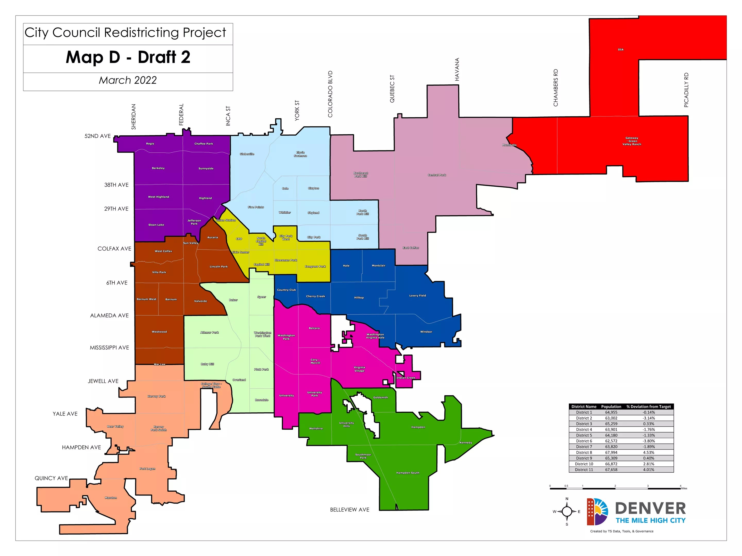
Map D is one of two maps remaining.
Denver City Council
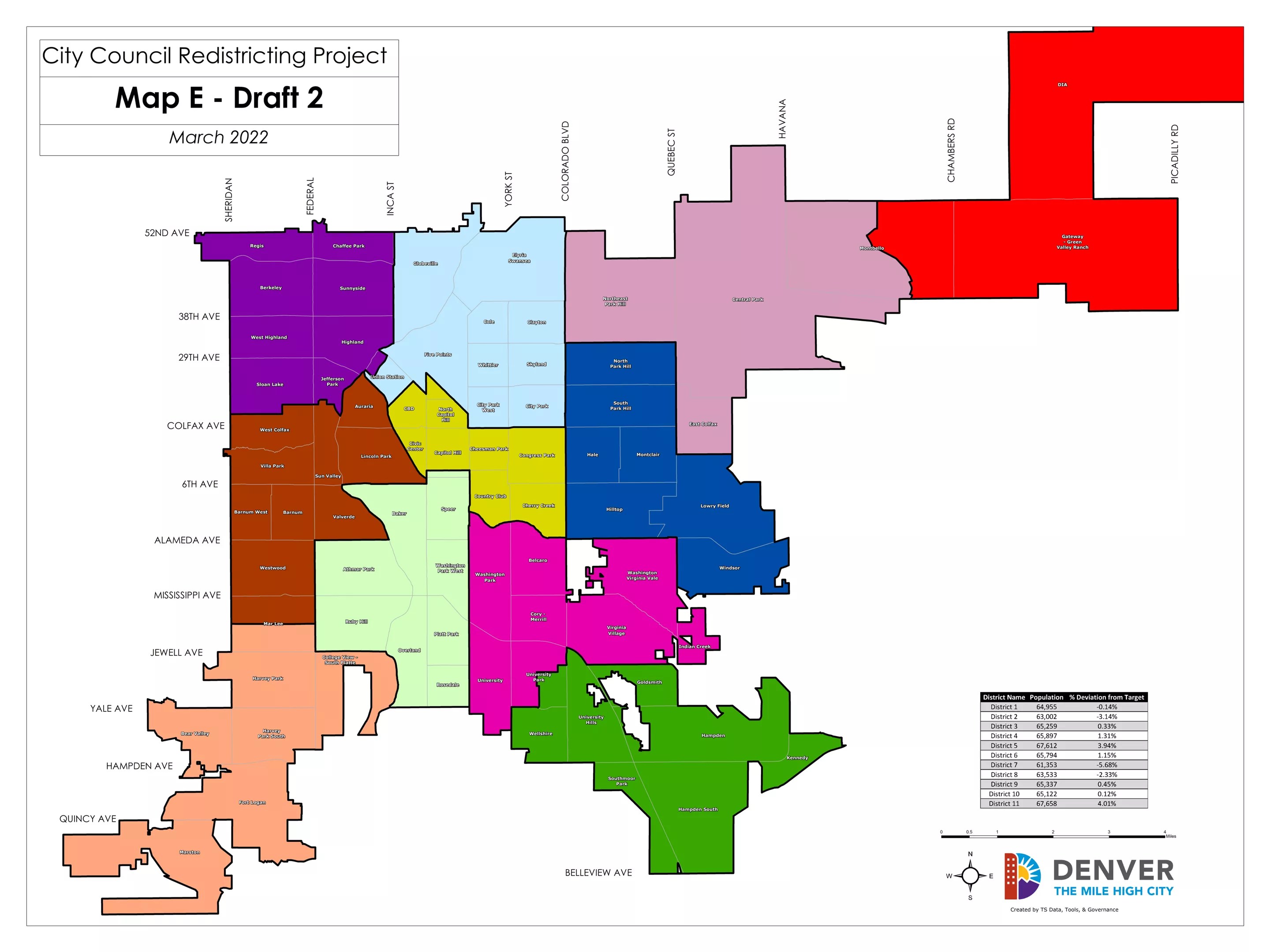
Map E is battling with Map D to become the final map.
Denver City Council