

Brandon Johnson

Audio By Carbonatix
Though it often seems like construction projects on Denver’s streets pop up and last forever without any thought given to how they might impact people, the city has an extensive transportation construction plan.
Recently, the Denver Department of Transportation & Infrastructure released a six-year outlook of construction projects in the pipeline, complete with a map showing where each project will occur. Much of the construction is concentrated in Denver’s city center where the street network is dense, but there isn’t an area of the Mile High City that isn’t scheduled to experience a construction project over the next six years.
The transportation department’s six-year outlook supplements the Denver Moves: Everyone 2050 plan, which explains the city’s transportation vision and the projects needed to get there.
“This map illustrates our Six-Year Capital Plan, which indicates priorities for transportation improvements based on alignment with the goals and vision set forth by the community in Denver Moves: Everyone,” according to DOTI. “This map also highlights active projects that are in motion as of 2025 and are in an active plan, design, or construction phase.”
Not every project in the six-year plan is guaranteed to be completed, or even begin, during that time as funding and feasibility could change, but DOTI views the map as a good window into where and when projects will take place.
City of Denver Construction Priories
According to the Denver Moves plan, Denver follows four policies when considering a project:
- How the project contributes to Denver’s Vision Zero plan to eliminate traffic deaths
- If the project encourages people to shift from single-occupany vehicles to other modes of transportation
- DOTI’s commitment to prioritizing people over personal vehicles
- Environmental sustainability
The six-year plan specifically highlights pedestrian, bikeway and transit improvements by letting people filter for those types of projects. Additionally, people can filter for bridge, signal and major multi-modal projects on the map. The map also lets people monitor progress on construction projects by allowing projects to be sorted by those in planning, formal design or under construction.
Along with labeling city construction projects, the map also gives insight into what parts of the city DOTI is examining for safety-related improvements. Within the next six years, roads highlighted in pink on the map will receive safety audits. During road safety audits, DOTI hires independent teams to examine potential road safety issues and opportunities for improvements.
Arapahoe Street and North Broadway in downtown Denver will both be audited for safety in the next six years, according to DOTI, and so will Downing Street from 26th Avenue Parkway to 38th Street, right next to One River North.
Farther out, the intersection of Sheridan Boulevard and Alameda Avenue and the blocks leading up to the intersection are scheduled for a safety audit.
The map also identifies safety focus areas, which are already slated for safety-related improvements, such as intersection or bikeway improvements identified by DOTI’s Neighborhood Transportation Management Plan program. Federal Boulevard from Bayaud to Evans streets, downtown Denver as a whole, the Broadway/Lincoln corridor from Civic Center Park to Alameda and the area between 14th and 16th street from Downing to Colorado Boulevard are among those areas. The Weir Gulch area of west Denver will receive a myriad of neighborhood safety projects in the next six years based on community feedback in 2024, according to the map.
Projects in Denver’s High Injury Network have their own color, while DOTI’s equity index can be overlaid on the map for those who want to examine which parts of the city are being prioritized.
Most categories on the map can be exported into a table for people who aren’t visual learners or who want to track down projects in depth. For people specifically interested in paving updates on roads, there is a filter for those, too.
Major Construction Affecting Denver Right Now
The map also helps track notorious and disruptive projects in Denver, such as the the 16th Street Mall project, an overhaul (and renaming) that took nearly three years but is slated to be completed later this year; the Colfax Bus Rapid Transit project is listed, as well. People can even see which signals and intersections are being redone as part of that massive transit development.
Other major projects in the pipeline include East Hampden Avenue corridor improvements between South University Boulevard and South Galena Street. There, construction is expected to begin later this month to improve several intersections and stretches of the road for pedestrian safety.
The on-off ramps between Hampden and Interstate 25 will also be under construction, which could lead to major rush-hour headaches, as construction is scheduled between the hours of 7 a.m. and 5 p.m. daily. Hampden is projected to be completed by Spring 2026.
Ongoing work around Broadway and I-25 is scheduled to last until Spring 2026. However, a new onramp was completed last fall and remaining construction should make traffic on the rest of Broadway flow smoother.
The remaining work on Broadway will add new signals at intersections on East Ohio and Kentucky avenues, improve bike-path connections to the nearby RTD hub and repave sections of Lincoln Street, Broadway and Kentucky and Ohio will all be repaved and refined after being muddled by construction for the last few years.
A pedestrian underpass being built along Alameda between South Cherokee Street and South Santa Fe Drive just started construction in March. On that part of the road, traffic is being reduced to one lane for the duration of the project, according to DOTI. The project uses $7 million in GO Bonds issued in 2017 to make the area ADA accessible and improve drainage while connecting people to commercial districts on either side of the street.
Check out other upcoming projects that could come to your streets in the next six years using DOTI’s map, pictured below.
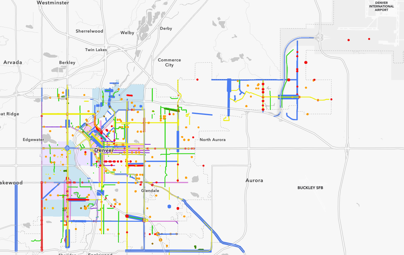
Denver construction map six-year outlook
Denver Department of Transportation and Infrastructure

Denver construction map key
Denver Department of Transportation and Infrastructure