
Denver.gov

Audio By Carbonatix
Independent Journalism in Denver Needs You
We need to raise $25,000 by August 9 to support the reporting our community depends on. Reader support keeps us independent and is playing a larger role in funding local journalism and shaping what comes next. If you believe independent local journalism matters, make a contribution today.
Every ten years, after U.S. Census results are tabulated and Colorado has established its new legislative lines, Denver City Council redraws the boundaries for council districts. The council is now deep in the redistricting process for a city that has grown by 115,000 residents over the past decade, with a final vote set for late March – a little over a year before the next council elections.
“I think it’s going great compared to what we had heard ten years ago for the need for more transparency, the need for community input, the need for looking at communities of interest,” says Councilwoman Amanda Sandoval, the council representative for northwest Denver who has been leading the redistricting efforts.
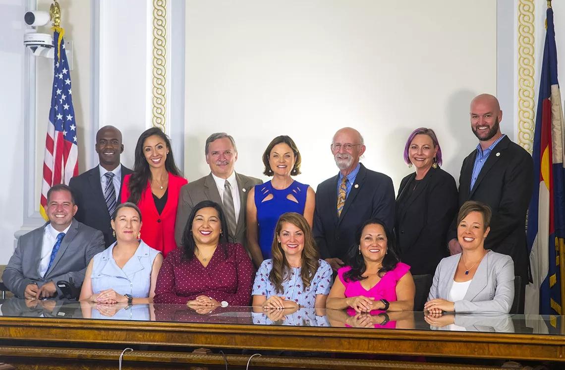
Five councilmembers – Jamie Torres, Candi CdeBaca, Kevin Flynn, Amanda Sawyer and Sandoval – have each mapped out their own proposals. Jolon Clark, Chris Herndon, Paul Kashmann, Chris Hinds, Kendra Black and Stacie Gilmore have joined together to propose a single map.
Denver has eleven council districts, each represented by one council rep; two councilmembers – currently Robin Kniech and Debbie Ortega – serve in an at-large capacity.
According to U.S. Census data, the population of Denver has grown from 600,158 in 2010 to 715,522 in 2020. Council maps are supposed to keep district populations within 10 percent of approximately 65,000 constituents; according to charter rules, the districts must also be as compact as possible and contain contiguous territory.
The redistricting process is a bit rushed this time, both because of a delay in the Census results and a ballot measure approved in November that moved the Denver City Council election from May to April in order to comply with state and federal voting rules.
While redistricting at the state legislature and congressional levels can often involve heavy gerrymandering along partisan lines to give Republicans or Democrats an advantage, the City of Denver doesn’t have to worry about such political maneuvering. Denver elections are non-partisan, and every member of Denver City Council these days is a Democrat, anyway.
However, incumbents can still plot out district boundaries in a way that’s advantageous to their reelection chances – or simply more responsive to the communities they represent.
“The red flag would be if you had a defined Hispanic community and that community was arbitrarily split so that an incumbent could maintain a seat who wasn’t necessarily considered someone who represented that community,” says Rebecca Theobald, a professor in the Department of Geography and Environmental Studies at the University of Colorado Colorado Springs. To prevent such system-rigging, the redistricting process “needs to be very transparent,” she says.
“I feel like they’ve been doing their best to get the word out there,” says Jonathan Pitocco, a resident of the West Colfax neighborhood who has gotten involved in the process. “You have to build a strong case for your map instead of just signing off on one.”
But Danielle Shepard, president of the East Colfax Neighborhood Association, feels that outreach has been lacking. “I would say it’s been almost non-existent,” she says.
Some of the maps proposed by councilmembers offer hints at what certain incumbents are hoping for in their new districts.
District 9 rep CdeBaca, for example, has proposed a map that would remove downtown Denver, including the area around Union Station, from her district. “I think that quartering up or cutting up downtown as much as possible is a win-win for everybody,” explains CdeBaca. “For example, the Auraria part of our downtown connects better to Lincoln Park. The Union Station part of our downtown connects better to the northside because of Park Avenue. It should be broken up in that way.”
In exchange, CdeBaca proposes that District 9 take other areas, such as the western edge of Northeast Park Hill and North Park Hill. That map could provide an election advantage for CdeBaca, who has positioned herself as a representative for people at risk of gentrification rather than business owners and wealthier residents in downtown Denver.
But CdeBaca says her map is about preserving a majority-minority district that has been threatened with dilution in past redistricting efforts. “Any time we’re preventing a majority-minority district, we are gerrymandering,” CdeBaca adds.
District 5 rep Sawyer has proposed a map that would cut out a portion of the East Colfax neighborhood, which is quite diverse and at risk of displacement, from her district and add the Cherry Creek and South Park Hill neighborhoods. Consolidating wealthier neighborhoods in District 5 could help the re-election efforts of Sawyer, who has positioned herself as a more conservative member of council.
But Sawyer, too, says that her own election chances didn’t influence her thinking.
“The East Colfax Neighborhood Association and the East Colfax Community Collective made it very clear that what they wanted was to stay together in that neighborhood and to be in District 8 so they could be with people who are like communities of interest, [like] people who are residents of Montbello and Northeast Park Hill,” Sawyer says. “I would be really disappointed to not represent that community anymore. I certainly understand their desire to be paired with residents in Northeast Park Hill and Montbello.”
The map that has the most buy-in from council reps is Map D, the one that’s been a joint project. “At the end of the last stakeholder meeting, plan D was the preferred plan,” Hinds says, referring to a February 2 virtual community meeting. “That suggests that these half-dozen councilmembers that worked on something together worked on something that got the most support.”
One of the most noteworthy changes in Map D is that District 10, which Hinds represents, would gain the downtown area from District 9. But District 10 would also lose neighborhoods to the south, such as Cherry Creek and Country Club, sending those over to District 5. And the East Colfax neighborhood would move entirely into District 8.
“I think that Cherry Creek is a great neighborhood,” Hinds says. “Country Club is a great neighborhood. I’m a bit sad to have that go, but also, downtown feels underrepresented right now, too, and I basically live downtown.”
According to Hinds, Map D’s biggest flaw is that it breaks up Capitol Hill. “Cap Hill, rightfully so, feels like it should be a community that is preserved,” Hinds notes.
For CdeBaca, Map D highlights one of the major flaws of the redistricting process. “We literally put into our council resolution that we were building districts around the current incumbents. That’s gerrymandering,” she says.
But Hinds counters that, suggesting that CdeBaca’s map “splits up a bunch of neighborhoods” and would even remove incumbents from their districts. “It was just kind of nuts,” Hinds says.
Between now and the final vote on March 29, Denver City Council will be collecting feedback from members of the public at community meetings. During this time, the final map can get “as much adjustment as is needed to stay within the criteria we have in our charter,” Sandoval notes.
And in the end, someone is bound to be unhappy, suggests Theobald: “Remember that no matter how you draw a map, someone will feel as though they are being stuck someplace, with people with whom they do not identify. This just happens because of population balance, no matter at what level you are redistricting.”
The six council-sponsored maps are below; click on each one to view at a higher resolution.
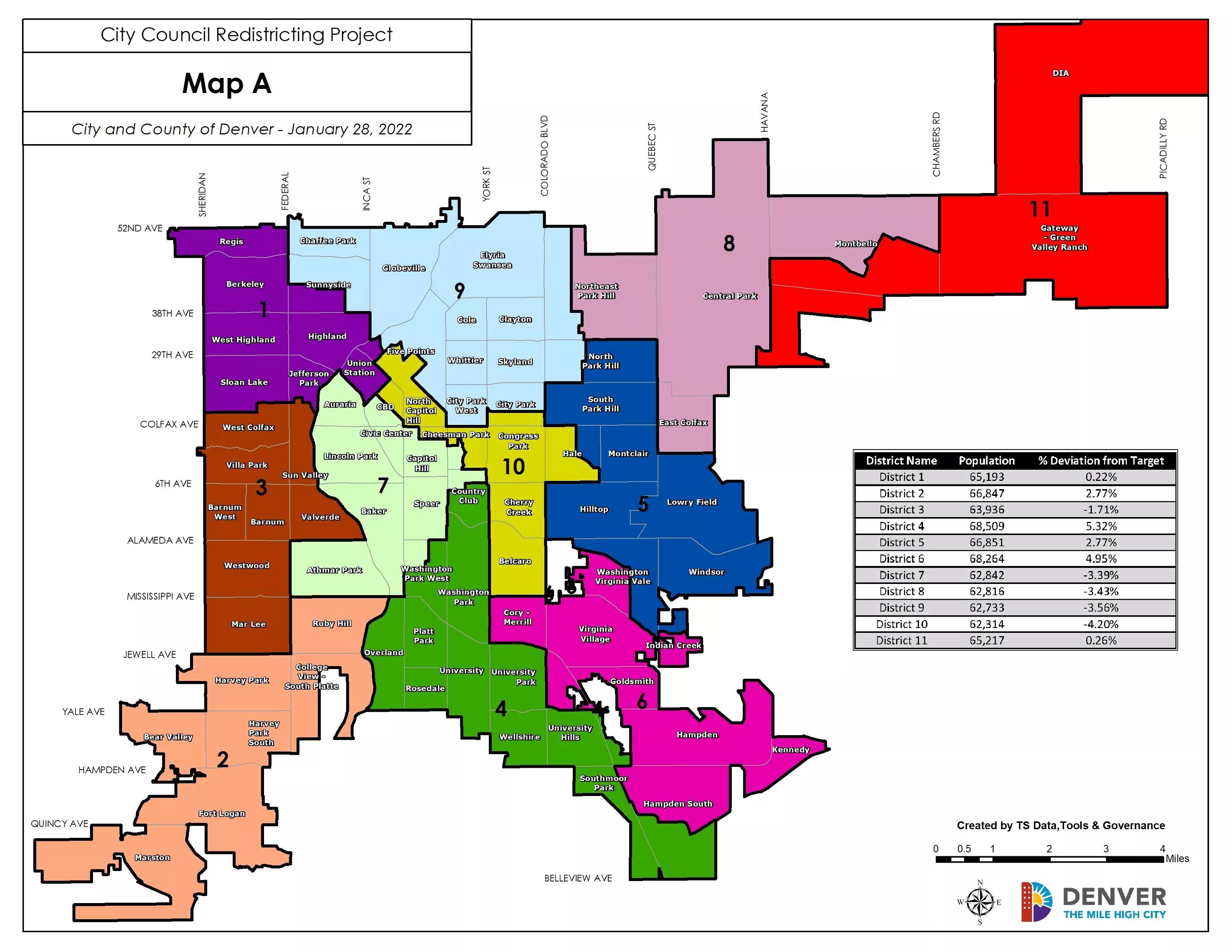
Map A, proposed by Councilwoman Candi CdeBaca.
City and County of Denver

Map B, proposed by Councilwoman Jamie Torres.
City and County of Denver
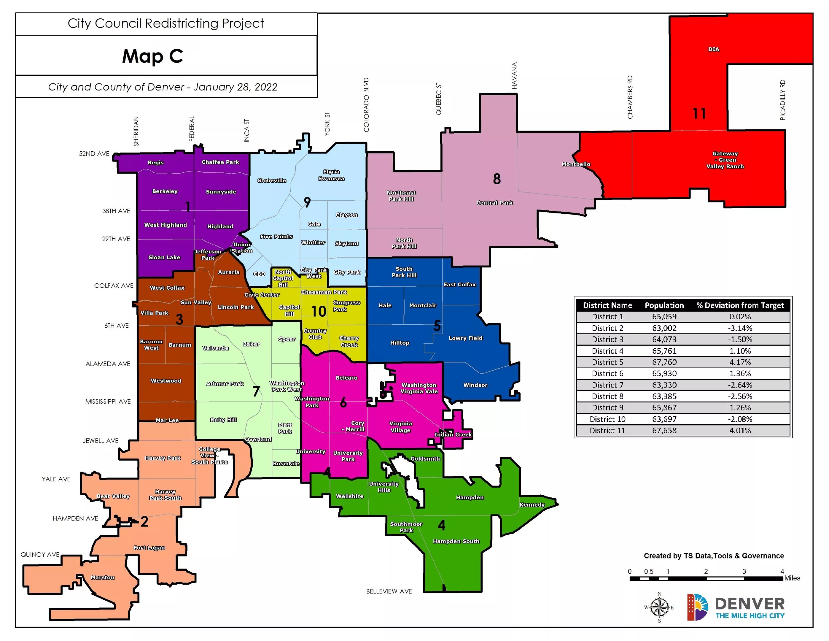
Map C, proposed by Councilman Kevin Flynn.
City and County of Denver
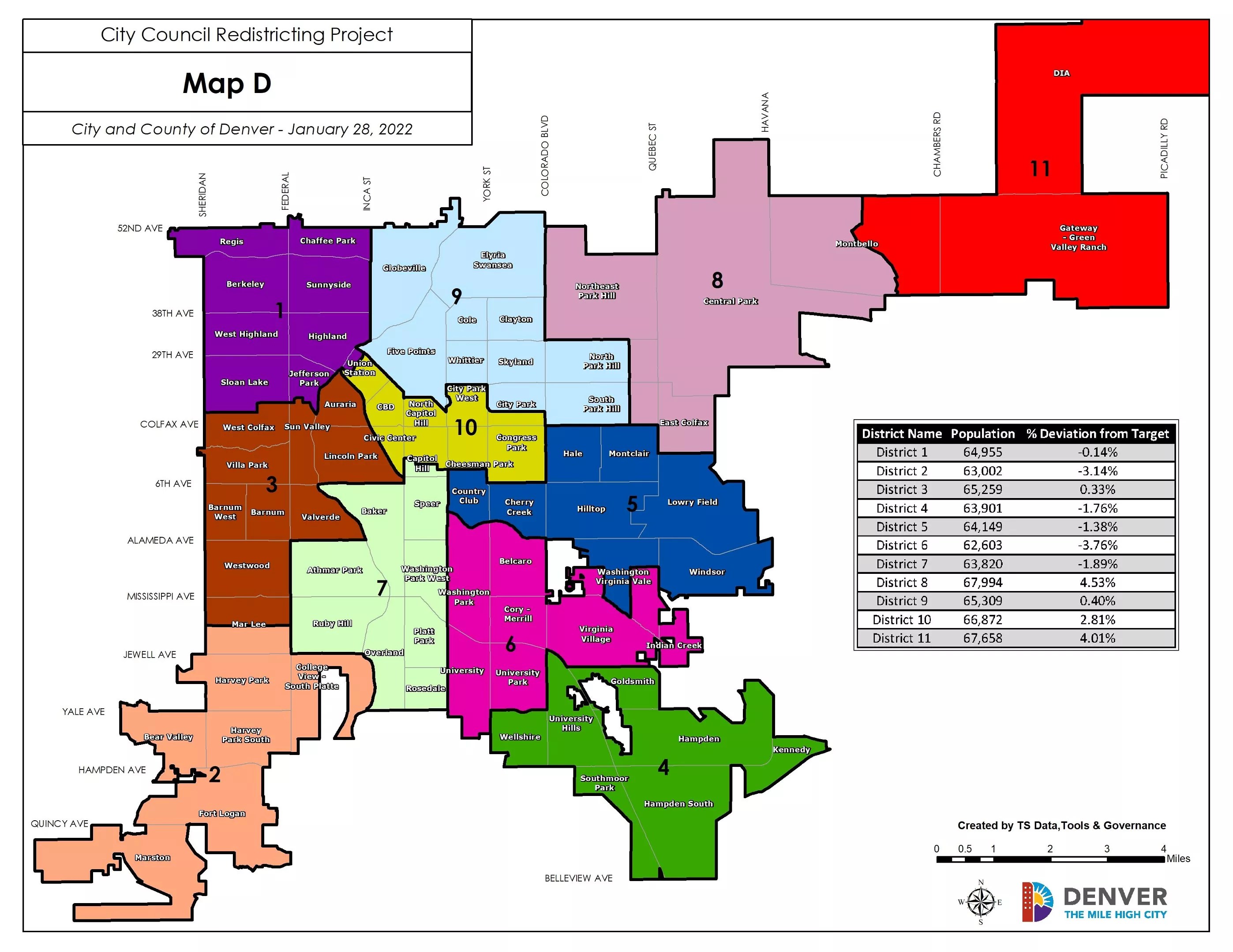
Map D, proposed by councilmembers Jolon Clark, Chris Herndon, Paul Kashmann, Chris Hinds, Stacie Gilmore and Kendra Black.
City and County of Denver
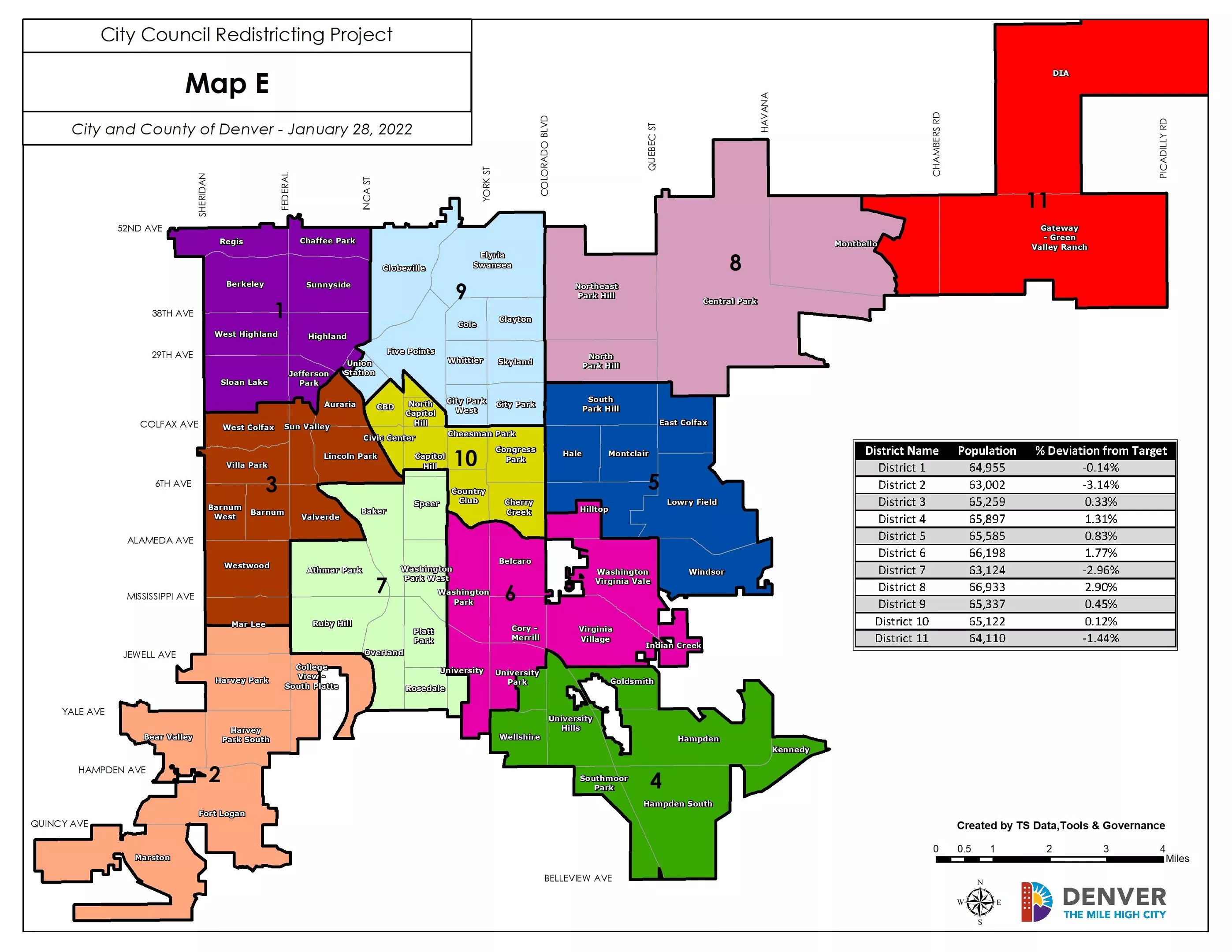
Map E, proposed by Councilwoman Amanda Sandoval.
City and County of Denver
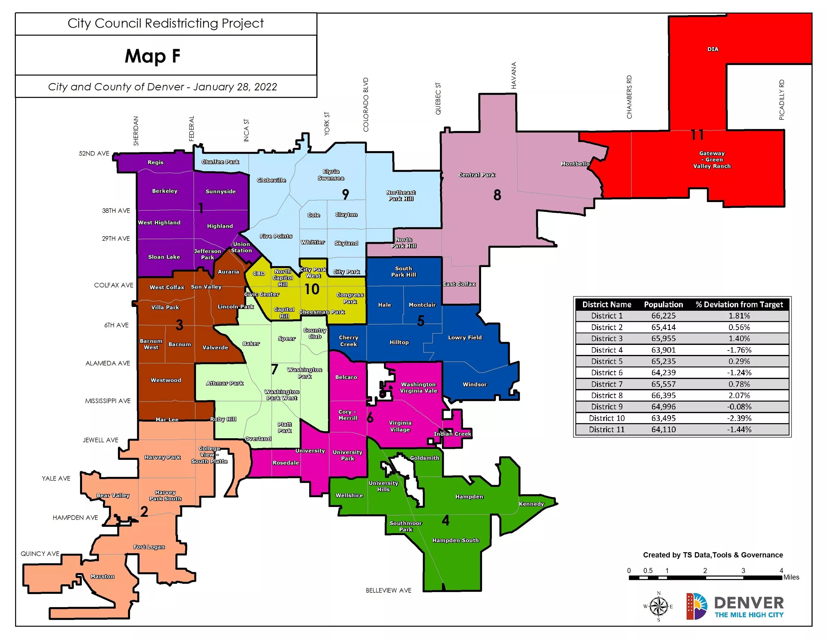
Map F, proposed by Councilwoman Amanda Sawyer.
City and County of Denver