

Kirby Quick

Audio By Carbonatix
Colorado’s favorite auto body stimulus package may be returning to Denver.
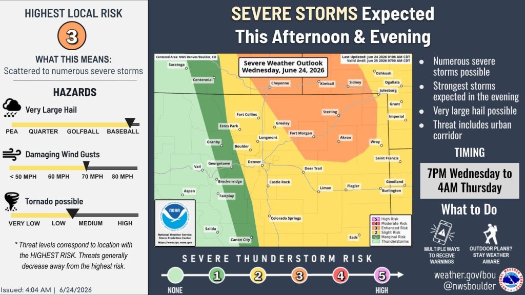
The National Weather Service and local meteorologists have predicted severe thunderstorms throughout the eastern part of Colorado on June 24, and those conditions could stretch into the metro, bringing about nearly three inches of hail.
Woohoo!
Two rounds of storms are expected to hit an area between Denver and the Kansas border. The first storm could arrive between 1-6 p.m., and the second, weaker storm is expected between 7-10 p.m., according to 9News meteorologist Chris Bianchi. The NWS has labeled the area a severe weather risk between 7 p.m. and 4 a.m., with possibilities of “baseball-sized hail” and winds up to 70 miles per hour. That warning includes the “urban corridor” (Denver), but the city less of a chance at experiencing severe conditions, with a 20% chance during the day and 40% chance at night.
This would make for the second day of severe storms in the state; Pueblo and Colorado Springs were rocked overnight on June 23, with some people reporting tennis-ball-sized hail just north of Colorado Springs, according to Interactive Hail Maps.
Pueblo, on the other hand, was pelted with 2.62 inches of rain during the storm and flash flood event Tuesday evening, leading to the city’s fifth-wettest day ever recorded and wettest June day ever, according to Bianchi. That smattering of rain accounted for 22% of the city’s annual rainfall in just two hours, a big flip from the abnormally dry months the state has trudged through.
Why the weird weather?
Colorado is known for weird weather, but why have the last few days looked so hail-centric?
Pot lids! Well, kinda.
Colorado has been experiencing a capping inversion, which is basically a layer of warm air a few thousand feet above the ground that acts like a lid. Hot air usually rises toward colder air above, but when a warm-air lid sits above air that is also warm, the lower air gets trapped. Weather remains tame if the surface air doesn’t heat up enough to break through the lid, but storms occur if the air below gets hot and moist enough.
“You have a boiling pot of water and a lot of rising heat, and then you clamp a lid down on that pot, and the party is over,” Kody Wilson, local meteorologist and online celebrity, said Tuesday. “At some point, this cap is going to break, because the lift generated by surface heating and easterly upslope winds will be strong enough for updrafts to punch through this cap, and when that happens, game on.”
Denver air didn’t reach the point of breaking the cap on Tuesday, but it still could on Wednesday with higher storm chances forecasted in the area.
The weather pattern has brought about some national attention, as well. Freddy McKinney, a Nebraskan tornado chaser who has over 500,000 subscribers on YouTube and has been featured on HBO’s In the “Eye of the Storm,” has been live-streaming tornado chasing in Colorado over the past few days. McKinney and his team have yet to see a twister, but did run into a monstrous storm outside of Wray.