

Flickr/Pam Broviak

Audio By Carbonatix
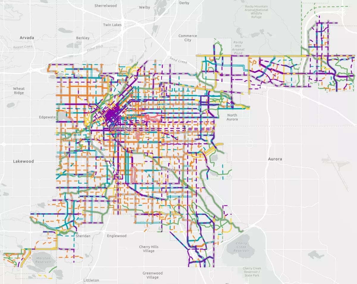
The City of Denver recently revealed plans for new bike paths over the next two decades with the Denver Moves: Bike Map. If followed through as planned, the city promises a sprawling network of streets and trails designed to make bicycling easier in the Mile High City.
Since August 2024, the Denver Department of Transportation and Infrastructure (DOTI) has been surveying residents online and at community meetings before upgrading and adding on to 500 miles of existing bike paths, with nearly thousands of residents responding to online surveys and in-person meetings.
The map shows six types of bike paths: basic bike lanes, protected lanes, neighborhood bikeways, shared sidewalks, car-free streets and trails. Lanes and bikeways are roads with sections set aside for cyclists while sidewalks, trails and car-free streets are the only paths that cyclists get all to themselves. Car-free streets are exclusively found in Denver’s largest parks, like City and Washington parks.
Funding to complete the paths, some of which requires City Council approval, is still needed, but the plan itself is finalized and will guide DOTI’s strategy to add another 220 miles of bike paths, according to the department. Here’s what cyclists (and car drivers) can expect if it plays out as promised.
New Bike Lanes, Sharrows Coming to Major Roadways
Nearly all of the new bike paths the city wants to build are lanes and bikeways. Neighborhood bikeways are roads with low speed limits and traffic calming measures, such as electronic signs, speed bumps and the large white icons painted on the street known as sharrows. Protected bike lanes are narrower but buffered with painted lines and flex posts.
DOTI uses bikeways for residential roads where traffic studies show drivers are slower. Protected bike lanes are on busier roads and closer to downtown, where traffic is denser and faster, and cyclists need more protection.
According to the map, north and central Denver will have long bikeways stretching from south of Interstate 70, through the Park Hill neighborhoods, past Glendale to the Cherry Creek Trail. The city’s existing neighborhood bikeways are much smaller, and mostly around the Highlands on roads like West 29th Avenue or Tennyson Street. South Denver will be getting bikeways with a similar length to those in the Highlands, which only go through a couple of neighborhoods.
Meanwhile, protected bike lanes will be added to some of Denver’s busiest streets, like Broadway, Monaco Parkway and West Evans Avenue. Most of Denver’s current protected bike lanes are located downtown and along Lower Downtown roads, like Blake, Market and Larimer streets, where the city is replacing old flex posts with small bumps called zippers.
If the city follows through on its plans, it will have a sprawling but seamless network of lanes and trails for cyclists to get around town.
Courtesy of DOTI
Missed Connections: City to Create a “Core Network”
A major goal of DOTI’s is connecting one-off trails to nowhere that aren’t part of larger routes. The map seeks to put an end to that by creating a “core network” that can be reached from any of the city’s bike paths.
Long neighborhood bikeways planned on thoroughfares like Dahlia, Holly and Oneida streets will overlap with existing and planned bikeways and bike lanes. The Oneida Street bikeway will connect Martin Luther King Jr. Recreation Center and James A. Bible Park, which are about 23 miles apart, and will intersect with lanes, bikeways and trails about every mile, especially on the north end.
Similarly, shorter bikeways in south Denver along west Mexico, Harvard and Warren avenues will be able to carry cyclists east and west and into trails like the High Line Canal and across a handful of neighborhoods.
Some of the protected bike lanes that the city plans to build will stretch alongside the street for miles and intersect with various paths, too. A protected lane on Broadway will go from the RiNo to Englewood; alongside a long protected lane on Speer Boulevard, it will open a route for cyclists to pour out of downtown and onto the larger network of paths.
Sharing is Caring: Most New Paths Won’t Exclude Cars
Studies and data show that Denver bike lanes are increasingly blocked by trash cans and parked cars, which forces them out into the road. Although Denver is already considered very bike-friendly, a perfect world for most cyclists includes having their own paths, free of cars, all over town.
But even the city had the power to implement its entire bike plan overnight, cyclists would still have to share their routes with cars. Many of the new lanes and bikeways will boil down to the city adding new paint to the roads to protect cyclists, but it won’t mean paving or digging new paths just for cyclists.
The exception will be the handful of new trails and sidewalks. One of the new trails will run just southwest of the Denver International Airport and branch off from sections of the High Line Canal in Green Valley Ranch. Another trail will go along Monaco Parkway from East 38th Avenue in Northeast Park Hill to East 6th Avenue Parkway in Montclair.
The Elyria-Swansea and Globeville neighborhoods in north Denver will get a few miles of a new shared sidewalk for cyclists and pedestrians around National Western Drive and Washington Street, which are near the South Platte River and the National Western Stock Show.