
Google Maps

Audio By Carbonatix
Anyone who’s been served up Instagram ads for something they were just talking about knows that phones are tracking our every move – and across some of Denver’s streets, the government is doing the same.
The City of Denver has around 200 BlueTOAD Bluetooth detection devices placed along streets that feed data to the Department of Transportation and Infrastructure (DOTI). These expensive gadgets identify how long it takes for a Bluetooth device such as a phone or vehicle to go from one detection point to the next, similar to the way Google and Apple Maps track people to determine the red, yellow and green traffic lines on their apps.
“We use the technology to track speed and travel time on city streets, and to see how speed [or] travel times are affected by improvements or changes we make,” DOTI spokesperson Cyndi Karvaski says. “For example, if we make signal timing changes on a corridor to slow speeds, we can look at the before-and-after data to see what impact we had.”
At a February 20 Denver City Council meeting, councilmembers Flor Alvidrez and Shontel Lewis asked about privacy before voting on a $1.2 million state grant extending the program.
“My general thoughts were what are we going to use this data for? How are we going to protect folks’ data?” Lewis says in an interview with Westword after the meeting. “Is there an opt-in or opt-out opportunity for folks, or does it just automatically connect to folks who are connected to Bluetooth? … I wanted to be sure that we were not unintentionally surveilling folks or collecting data that we shouldn’t be that folks didn’t know we were collecting.”
The department reassured councilmembers that Denver travelers’ phone data is safe, and that the city isn’t tracking who goes where. According to DOTI deputy manager Nicholas Williams, Bluetooth data received by the city has already been scrambled.
The council was considering a $1.2 million grant from the Colorado Department of Transportation that would allow DOTI to purchase an additional 110 Bluetooth detection devices. At the meeting, Williams confirmed that there is not a method to opt in or out, but reiterated that DOTI has no way to access personally identifiable information.
“It’s completely scrambled on [the device],” Williams reiterated during the meeting. “There’s no way we could tell who that was. Even if that data was subpoenaed, all we could provide would be that scrambled data that you really couldn’t track to anyone.”
The data is not publicly available and is only used internally within the department, he added.
Lewis was satisfied with DOTI’s answers but still hesitates to fully vouch for the privacy of the program. She has concerns about whether data can truly be secure in any case.
How Bluetooth Tracking Impacts Traffic
Greg MacKinnon, a program manager for transportation operations with the Denver Regional Council of Governments (DRCOG), says the device is actually reading the media access control (MAC) address of devices, which are generally not registered to a database or tied to a specific person, although MAC addresses can be tracked if identified.
“You’re pretty safe to say it’s anonymous,” MacKinnon explains. “You could take some time to find out what your MAC address is for your phone, but people won’t know that it’s you. It’s not attributed to you.”
Over the years, DRCOG has helped cities deploy a network of the Bluetooth tracking devices around metro Denver to better understand how traffic is flowing in the area. As part of the DRCOG Regional Transportation Operations and Technology Strategic Plan, the council has helped Denver with funding for the detection devices in the past.
The organization previously shared such information with CDOT before the department updated to a new system. Now DRCOG is working to find a new way to share the data among Denver metro municipalities, according to MacKinnon.
“As you can imagine, Denver is only really interested in what’s happening in Denver, in terms of doing their job, but things that happen just outside of Denver are going to impact them,” he says. “So being aware of what’s happening out there is going to be a benefit to them.”
The eventual goal is to improve multimodal transportation operations by analyzing traffic patterns and data from specific regions, MacKinnon says. Although Lewis has reservations about the privacy aspect, the councilwoman supports the idea of more intergovernmental research.
“I’m always excited to see not only the state partnering with the city, but with cities partnering with cities and municipalities, and jurisdictions really reaching across lines to better service folks,” she says. “It’s really, really important that we are intentional about how the cities and the state are interfacing to improve traffic safety and pedestrian safety for individuals.”
According to DOTI, that’s part of the goal of expanding the Bluetooth detection network.
“With the expansion of this program, what we’re going to be able to do beyond just traffic analysis is really do better data analysis – as we’re doing traffic calming and different safety projects – to allow us to see before-and-after data with the expectation we should be seeing speeds going down in these areas,” Williams added at the February hearing.
The city also uses Bluetooth data to determine where there may be a crash or emergency occurring that has slowed traffic. Plus, the network of detection devices can show daily driving trends, such as the way traditional morning and evening commutes across the city were no longer peak travel times during the COVID shutdown.
“The Bluetooth devices help us to understand speed and travel times on city corridors, helping us make more data-driven decisions as we work to keep people moving safely and efficiently,” Karvaski says.
You just can’t choose whether your driving is part of that data or not.
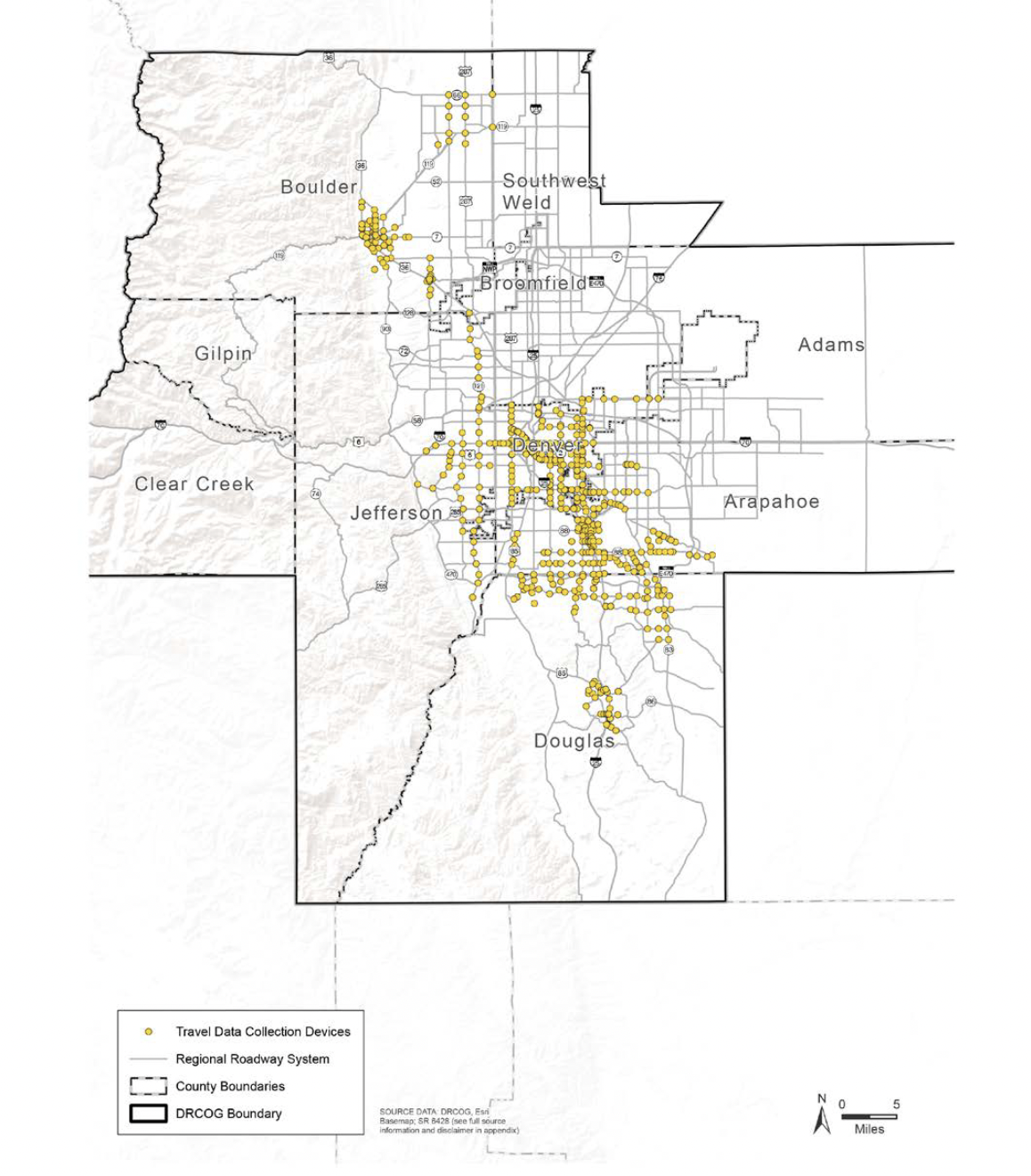
A map of all the Bluetooth detection devices currently in and around Denver.
Denver Regional Council of Governments