

Audio By Carbonatix
Keep Westword Free
We’re aiming to raise $20,000 by April 26. Your support ensures Westword can continue watching out for you and our community. No paywall. Always accessible. Daily online and weekly in print.
The folks at the Colorado Department of Natural Resources and Colorado Parks and Wildlife want you to venture into the great outdoors and experience the incredibly abundant wonders of our fair state – and COTREX, their brand new app, makes it simpler than ever to do so.
Where to start? That’s the question we put to CDNR trails and recreation project manager Alex Dean. Below, Dean offers the basics on COTREX, which provides detailed maps, descriptions, photos and more on an astonishing 39,829 miles of public trails in Colorado and 2,350 trailheads. In addition, he created a curated list of recommended trails with a variety of uses in mind specifically for Westword readers.
Today, in part one of our series, Dean focuses on easy trails that everyone can enjoy. For part two, coming soon, he’ll highlight moderate and difficult trails.
“It’s built from the ground up,” Dean says of COTREX, a project launched under former Governor John Hickenlooper’s 2016 Colorado the Beautiful initiative. “We spent three years doing outreach to 236 land managers in cities and counties across the state. It’s the most comprehensive data we could find, and it’s very active and dynamic. If you click on hiking trails, the app will show you ones you can legally hike on. If, the next day, you want to go mountain biking, you click on that and the whole map changes.”
What makes the application unique, he continues, “is that it focuses on the most official or authoritative trails we could come across. It’s not just user-generated data. These are the ones approved by land managers, so you know that you can legally recreate on them – and other states are watching this closely. Some of them have mapped their own lands, but we’ve mapped all the trails on federal, state, local and private lands with public access. So Colorado is the first state in the nation to do anything on this scale.”
That’s not all. According to Dean, COTREX also gives users “the ability to download maps, so you can look at them offline if you don’t have cell coverage. And there’s also a measurement tool that allows you to make a custom route. There’s a compass symbol on the mobile and web version, where you can click on a trailhead and put your finger or cursor on there and it will give you accurate distances for the hike. You can make it any shape you want, and the new functionality allows you to share these custom maps with friends and family.”
Over time, Dean says, the app will continue to evolve and improve: “It’s an ongoing process, and there’s a feedback mechanism that will help alert us to things that might need to be altered. But it’s an awesome start.”
Continue for five easy trails to get you going, complete with links and descriptions by Dean.
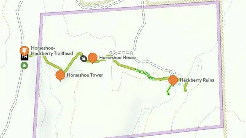
The route of the Horseshoe and Hackberry Ruins hike.
KID-FRIENDLY ROUTE
Horseshoe and Hackberry Ruins
Canyons of the Ancients National Monument near Cortez
Total length: 1.3 miles
Total ascent: 145 feet
“We define easy trails as ones with no or limited steep hills, and no loose footing or difficult terrain – and if you’ve got young kids, that may be what you want. This one is in southwestern Colorado, and because the ascent is only 145 feet, it’s pretty flat, so it should be good for kids of all ages. Along the way, there are structures built approximately 800 years ago by the ancestors of the Puebloan people. They’re really cool, and I think kids will enjoy seeing them.”
ROUTE FOR ATVs and FIFTY-PLUS INCH SIDE-BY-SIDES (UTILITY TASK VEHICLES)
Four Mile North RZR Loop
Along the Arkansas River near Chaffee
Total length: 25 miles
Total ascent: 3,306
“These vehicles are really popular, and some towns in Colorado have rental fleets of them. This trail is in Chaffee County, just north of Buena Vista. It’s part of the Fourmile travel management area, which has around 100,000 acres of National Forest Service and Bureau of Land Management lands. The trail is a motorized loop that is okay for all three vehicle classes: side-by-sides, ATVs and motorcycles. Along the route, there’s a lot of open areas, so there are going to be beautiful views.”
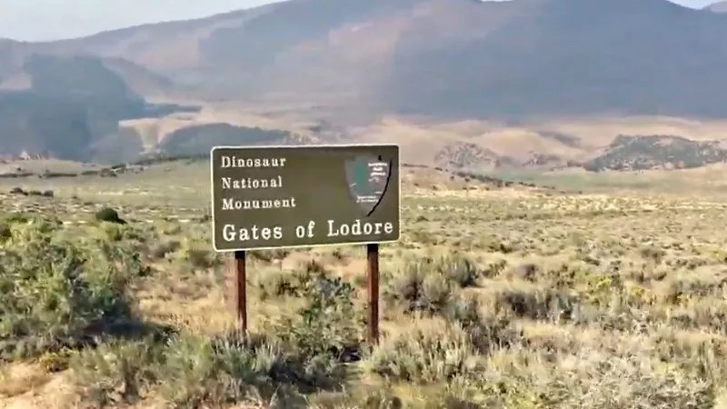
On the way to the Gates of Lodore.
NORTHWEST COLORADO
Gates of Lodore
On the Green River in Dinosaur National Monument
Total length: 0.9 miles
Ascent: 189 feet
“It’s a long drive to the area, which is on the northern tip of Dinosaur National Monument, and there are some sensitive areas where there’s no access. But the trail starts within a few steps of the trailhead, and it’s a pretty level walk along the Green River that ends with a view of the entrance of the canyon. It’s a very short hike and very easy to do. Most of the effort is driving to it. But if you’re looking for a little more isolation in the northwest part of the state, this is a gorgeous hike to do.”
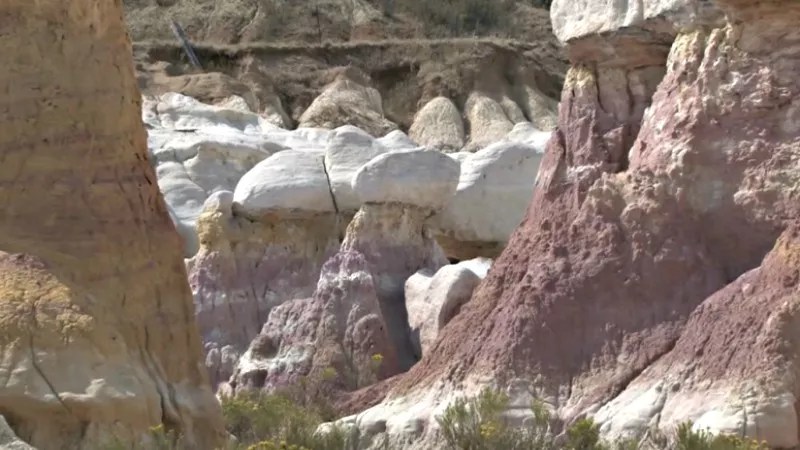
GEOLOGY HIKE
Paint Mines Interpretive Loop
Paint Mines Interpretive Park near Colorado Springs
Total length: 3.8 miles
Ascent: 386 feet
“This trail is a little bit north and east of Colorado Springs, and you might think it’s out of place on the eastern prairie because it features a lot of spires, including ones called hoodoos. When you go there, you’ll see layers of oxidized clay, and a lot of them are very colorful. They were an integral part of Native American culture, because they were used as paint and other dyes, and there’s evidence that humans used the site dating back 9,000 years. This is definitely a sensitive area where you’re restricted to the designated trails, and there are no dogs or bikes allowed. But this is a nice one to go on with your family. It’s very kid-friendly, too, and the rocks are incredible. They look very lunar, with really vivid orange and other colors – and because the ascent is only 380, it’s a pretty easy up and down.”
NATIVE AMERICAN HISTORY HIKE
Sand Creek Massacre Monument and Bluffs
Sand Creek Massacre National Historic Site, near Eads in Kiowa County
Total length: 3.75 miles
Ascent: 120 feet
“The Sand Creek Massacre is a tragic part of our history, but one we shouldn’t forget. In November of 1864, nearly 700 soldiers killed more than 230 members of the Cheyenne and Arapaho tribes, including women, children and the elderly, and the site tells the story of what happened. The hike itself is relatively flat and wheelchair-friendly, although, depending on the weather, rain, snow and small patches of sand can be a factor on wheelchair use. And in the summertime, the temperature in the area can get over 100 degrees, so it might be better to visit either early or late in the summer season. But this is definitely a place that everyone in Colorado should visit.”