


Audio By Carbonatix
The Colorado the Beautiful initiative, launched under the auspices of the state’s Department of Natural Resources, has what project manager Chris Kehmeier calls “an overarching goal: to have every citizen of Colorado live within ten minutes of a trail, park, greenway or open space that they can get out and recreate in.” And the first sixteen trails planned for construction under the program will go a long way toward turning this vision into reality. Get a preview of them below.
The trails were originally known as “16 in 2016,” but that’s something of a misnomer given the slow roll-out of the project. “Each trail is largely controlled by a local proponent group that’s pushing it along,” Kehmeier notes. “In 2016, we made advances, but nothing has been completely built yet. We have funding lined up for construction to start on a few in 2017” – specifically the Colorado Riverfront Trail in Mesa County and the Eagle Valley Trail in Eagle County – “and we’re also looking at getting the planning, engineering and environmental reviews done on quite a few more this year.”
According to Kehmeier, the assorted trails were chosen because “they represent missing links, gaps. They’re key trails that really fulfill the trail vision in Colorado, connecting communities to communities, connecting federal lands to communities, connecting trails to trails. They’re really trying to make some larger routes within the state.”
Also moving forward is the Colorado Trail System Map project, which Kehmeier says is setting out “to map every single trail in the state of Colorado. We’re reaching out to every trail manager in the state, whether they’re at the federal, state, county or municipal level, and even quite a few nonprofits that manage trails, then getting their data and putting it on a single map.”
The launch date for the map is June 3 of this year, which coincides with National Trails Day. Those working on the project have released an alpha version of the map to data providers so they can review the information related to their specific trails and make sure everything is correct. A beta version will follow for peer review in advance of the map’s anticipated June debut.
Will each Coloradan be ten minutes or less from one of the aforementioned recreational spaces by the time everything’s done? “We don’t have a complete picture yet,” Kehmeier acknowledges. “It’s still a work in progress. But early signs are definitely positive, and I’m optimistic that it’s possible.”
Continue to learn more about the first sixteen trails, complete with maps and text courtesy of the Colorado the Beautiful project.
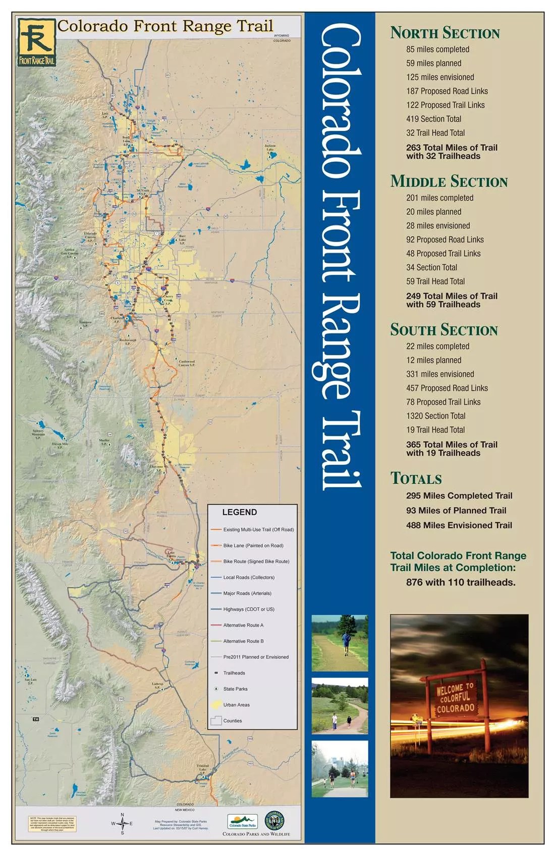
Colorado Front Range Trail.
Colorado Front Range Trail
The vision of the Colorado Front Range Trail (CFRT) is to create a multi-use trail extending from the borders of Wyoming to New Mexico along the Front Range that links diverse communities, scenic landscapes, cultural and historic points, parks, open space and other attractions. While significant portions of the almost 900-mile trail have been completed, almost two-thirds of the trail remains to be constructed. Several segments have been identified as priorities, including:
• The Walsenburg to La Veta and La Veta to Cuchara segments in Huerfano County would provide critical connectivity between communities to offer active, multi-modal transportation options to residents.
• The St. Vrain Greenway to Firestone segment will connect the City of Longmont with St. Vrain State Park and the City of Firestone.
• When complete, the Poudre River Trail will provide a segment of the CFRT that is a nearly 40-mile, 10-foot-wide concrete trail and stretches along the Poudre River between Greeley, Windsor, Timnath and Fort Collins. Three trail gaps remain in this segment that prevent safe crossings from Fort Collins into Timnath, Windsor and Greeley.
• The Pueblo West Metro District to Lake Pueblo State Park segment will connect to the park’s existing paved trail system and to the greater Pueblo city trails. Currently, there is no formal connection from Pueblo West to Lake Pueblo State Park. This connection will provide a safe trail connection for bike or pedestrian use.
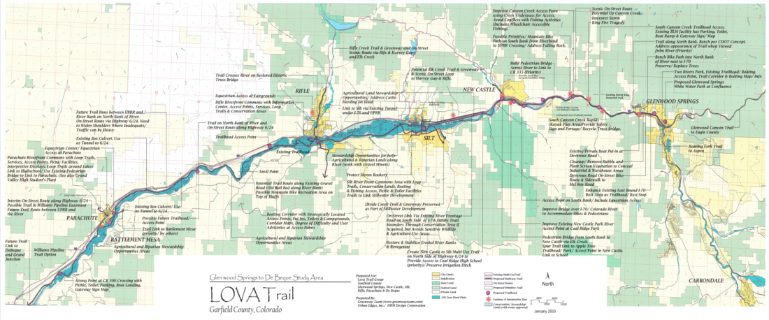
Lower Valley Trail.
Lower Valley Trail
The Lower Valley (LoVa) Trail is a multi-use, non-motorized trail that will travel through the Colorado River Valley beginning in Glenwood Springs to connect the communities of New Castle, Silt, Rifle and Parachute. Once complete, the paved trail will end at the Mesa County line and also will connect to the existing Rio Grande and Glenwood Canyon Trails beginning in Glenwood Springs. This regional trail will enhance outdoor recreation opportunities, will provide a safe transportation alternative for residents, and will connect residents of Garfield County to existing trails systems. The vision of the LoVa trail began as a grassroots effort in 1999. The proposed 47-mile trail is divided into five connector segments, with the first priority for construction being the South Canyon Trail section. To date, two small sections within the South Canyon and localized trails within each community have been completed.

Rocky Mountain Greenway.
Rocky Mountain Greenway
The vision of the Rocky Mountain Greenway (RMG) is to connect the Rocky Mountain National Wildlife Refuge to Rocky Flats National Wildlife Refuge, and Rocky Mountain National Park. A partnership between the U.S. Department of the Interior, Federal Highway Administration, CDOT, Colorado DNR and local governments, a mix of paved and natural trail will connect Front Range communities with unique wildlife resources and protected lands and complete a missing link in the Colorado Front Range Trail. To date, the trail work to connect the Rocky Mountain Arsenal and Rocky Flats is nearly complete, and an $8M award from CPW and GOCO in 2015 will support construction of the Boulder-Lyons segment beginning in 2016.
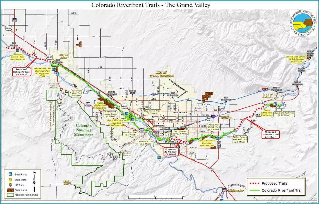
Colorado Riverfront Trail.
Colorado Riverfront Trail
The Colorado Riverfront Trail extends from Palisade through the Grand Valley communities of Grand Junction and Fruita and terminates at the Kokopelli Trailhead outside of Loma. To date, 23 miles of the trail have been constructed, with 10 miles remaining to fully complete the Riverfront Trail spine. Once completed, the continuous trail system will create a non-motorized, multi-modal transportation corridor that will act as an economic driver across the region and will provide access to additional recreation amenities such as the world-class mountain-biking opportunities at the Kokopelli trails. Portions of the trail will include a natural-surface single-track trail alongside the concrete trail to provide for alternative surfaces.
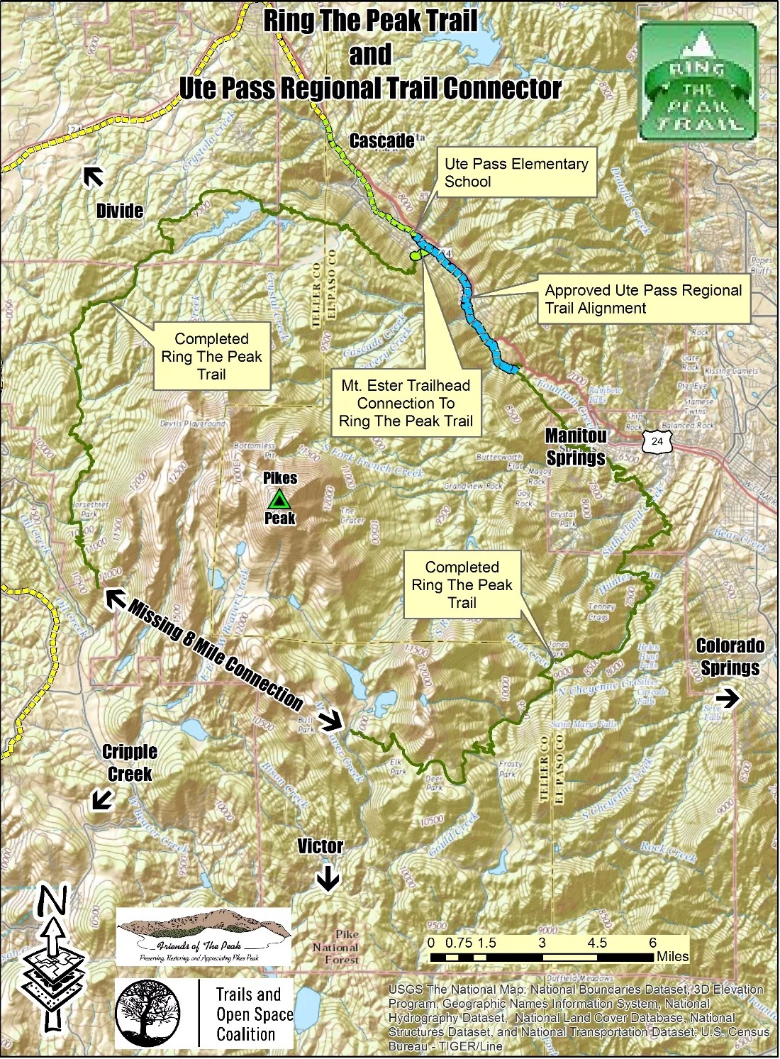
Ring the Peak.
Ring the Peak
Ring the Peak is a natural-surface trail system planned to circumnavigate Pikes Peak and was first envisioned in the 1999 Pikes Peak Multi-Use Plan. Two trail gaps remain to close the almost 62-mile loop. The Ute Pass Regional Trail is a proposed 11-mile segment from Manitou Springs to the El Paso County line. Completing the remaining five miles of the Ute Pass trail would close the northeast gap of the Ring the Peak Trail. This segment would also provide a connection to the American Discovery Trail and the America the Beautiful Trail.

Peaks to Plains Trail.
Peaks to Plains Trail
The Peaks to Plains Trail is envisioned as a 65-mile, 10-foot-wide, concrete east-west trail corridor from the Continental Divide at Loveland Pass to the South Platte Greenway north of Denver. Segments of the trail are built through both Clear Creek and Jefferson Counties. Currently there are several sections that are incomplete. Clear Creek County is working to finalize the design of approximately 16 miles of trail from the town of Empire to Hidden Valley as well as an effort to connect into the Jefferson County portion of the trail in Clear Creek Canyon. Jefferson County is focused on construction of a 2.5-mile segment at the west end of Clear Creek Canyon as well as finishing the design on the final 8-mile segment out to Highway 6 in Golden. An estimated 2.9 million Colorado residents and visitors will utilize the trail annually.

High Line Canal.
High Line Canal
The High Line Canal begins at the mouth of Waterton Canyon in Douglas County and winds 71 miles northeast to Green Valley Ranch in Denver. Over 350,000 residents live within one mile of the canal. The existing trail has over six major trail interruptions and 81 at grade crossings. Enhancements, trail connections, underpasses and other safety improvements are necessary to fill gaps in the trail, which will improve user safety and enhance the trail experience.
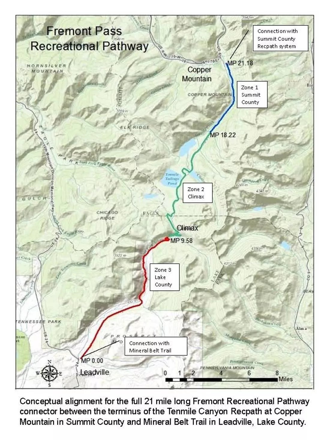
Fremont Pass Trail.
Fremont Pass Trail
As envisioned, the 21-mile Fremont Pass Trail will parallel Highway 91 over Fremont Pass connecting the Summit County recreation path system at Copper Mountain with the Mineral Belt Trail in Leadville. The trail will serve as an important connector between Summit and Lake counties by offering regional connectivity throughout Colorado’s central mountains. An analysis by the U.S. Forest Service to assess environmental impacts will be necessary to advance the project, and proponents expect that process to begin in 2016.
Continue to see eight more trails planned for the Colorado the Beautiful project.
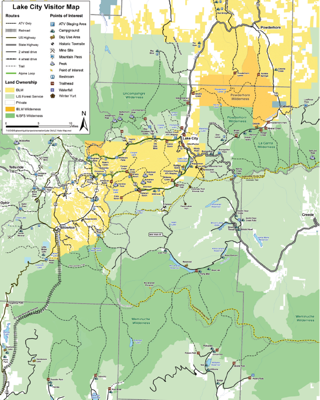
Alpine Loop Backcountry Byway.
Alpine Loop Backcountry Byway
The Alpine Loop Backcountry Byway is a multi-use, natural-surface trail that is heavily used by OHV traffic connecting Silverton and Ouray. A 1.5-mile gap near Lake City needs to be filled to complete the 64-mile natural-surface trail that carries motorized and non-motorized users between scenic Silverton and Ouray. An environmental impact assessment will be necessary to advance this project.
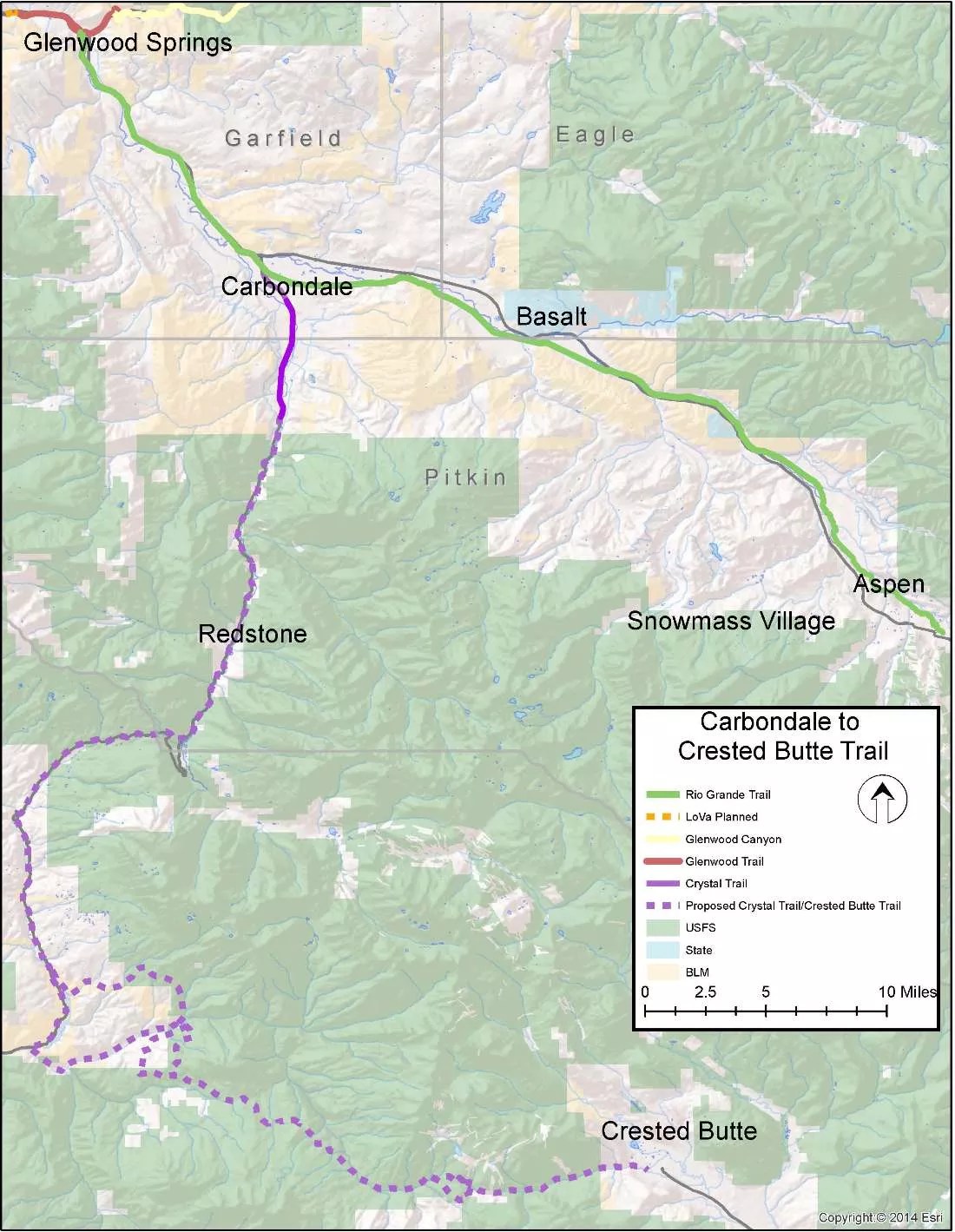
Crested Butte to Carbondale Trail.
Crested Butte to Carbondale Trail
The 74-mile Crested Butte to Carbondale Trail was first envisioned in 2004 to provide both paved and natural-surface trail opportunities to the communities of Carbondale, Redstone and Crested Butte. The first five-mile segment of the trail is complete, linking Carbondale to the existing Rio Grande trail. The next step is to complete the 17-mile Crystal Valley segment, linking the trail to Redstone and McClure Pass.
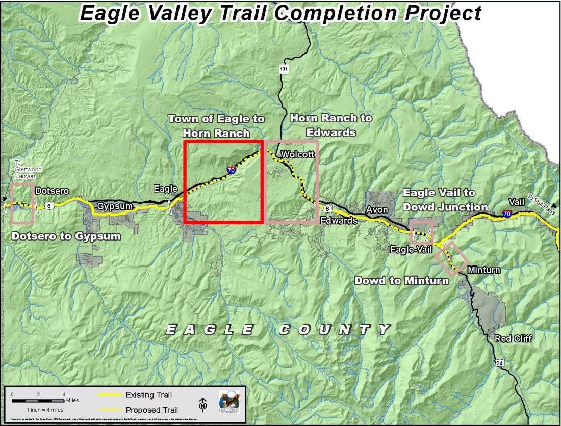
Eagle Valley Trail.
Eagle Valley Trail
When complete, the Eagle Valley Trail will be a 63-mile paved trail that travels the length of the Eagle River Valley, from Dotsero to the Town of Minturn. The trail will connect to the Gore Valley Trail through Vail and the Vail Pass bike path. Approximately 37 miles of the trail are complete and in use today. The next priority segment is seven miles from the Town of Eagle to the 287-acre Horn Ranch Open Space Park – connecting users to recreational opportunities in the park as well as other nearby public lands.
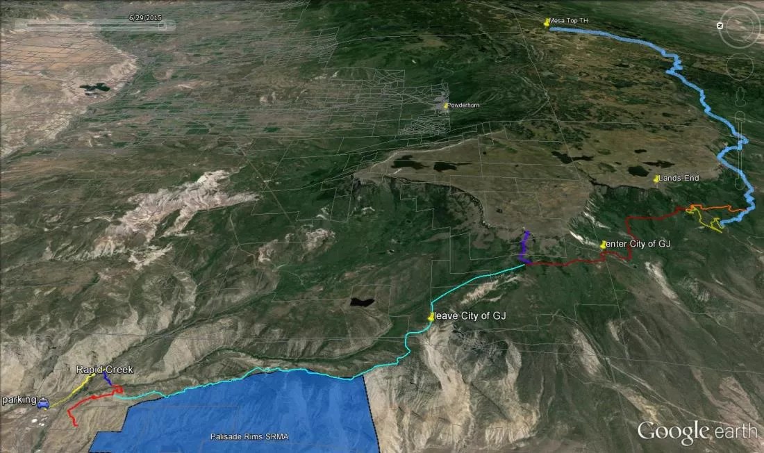
Palisade Plunge.
Palisade Plunge
The Palisade Plunge, located in Mesa County, is a proposed natural-surface single-track trail that begins at the Mesa Top Trail and ends at Rapid Creek Road near the town of Palisade. This project would provide unique and high-quality recreational trail opportunities connecting areas of diverse terrain to local municipalities and services. Users would have access to the Town of Palisade, the Town of Mesa, and Powderhorn Mountain Resort. An environmental impact analysis will be required to move this concept project forward.
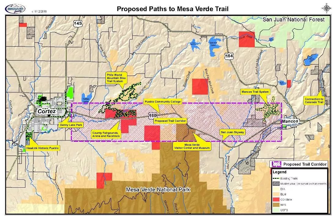
Paths to Mesa Verde.
Paths to Mesa Verde
The Paths to Mesa Verde project would provide 16 miles of multi-modal linkages between the Town of Mancos, Mesa Verde National Park, Cortez High School, Southwest Colorado Community College, the Phil’s World Mountain Bike Trails System, and the Montezuma County Fairgrounds. The trail would act as a safe transportation route along the Highway 160 corridor and would spur economic development surrounding tourism, outdoor recreation and cultural resources. Proponents expect to identify a preferred alignment and complete the preliminary design work in 2016.
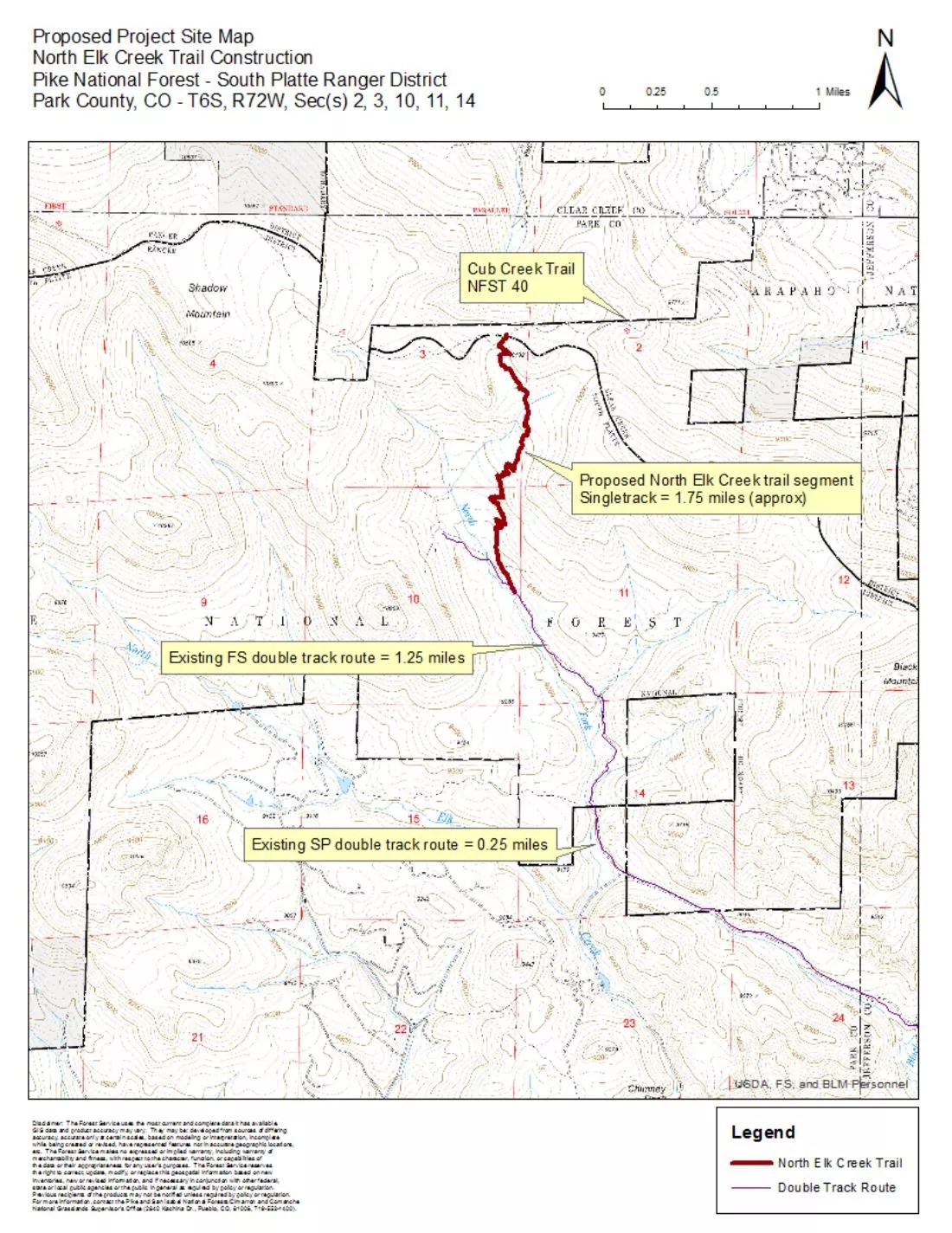
North Elk Creek.
North Elk Creek
The North Elk Creek Trail would connect Staunton State Park’s trail system to the Cub Creek Trail and Mt. Evans Wilderness in the Pike National Forest. The natural-surface single-track trail would serve the mountain foothill communities of Aspen Park, Conifer, and Evergreen and would be an integral link to the Town of Bailey’s planned trail system. An environmental impact assessment has been completed, and with adequate funding, the project could be completed in 2016.
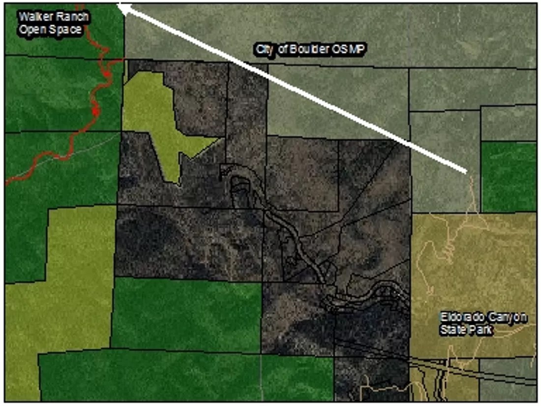
Eldo-Walker Trail Connection.
Eldo-Walker Trail Connection
The Eldo-Walker Trail would be a 1.5-mile natural-surface trail to connect non-motorized trails within Eldorado Canyon State Park to the Walker Ranch trail system in Boulder County.

Arkansas River Stage & Rail Trail.
Arkansas River Stage & Rail Trail
The envisioned 64-mile trail would be a long-distance, historically focused pathway connecting Salida, Buena Vista and Leadville, incorporating portions of the Leadville Stage Road and the Colorado Midland Railroad traveling through Chaffee and Lake Counties. The trail will include multiple segments comprised of a variety of surfaces. Multiple towns, counties, and state and federal agencies all have partial ownership and are responsible for certain portions of the proposed trail segment. Pending funding will support initial coordination and planning among all interest groups. An environmental impact analysis will be required to move the concept project forward.