
Kelly Clark, CDOT

Audio By Carbonatix
Keep Westword Free
We’re aiming to raise $20,000 by April 26. Your support ensures Westword can continue watching out for you and our community. No paywall. Always accessible. Daily online and weekly in print.
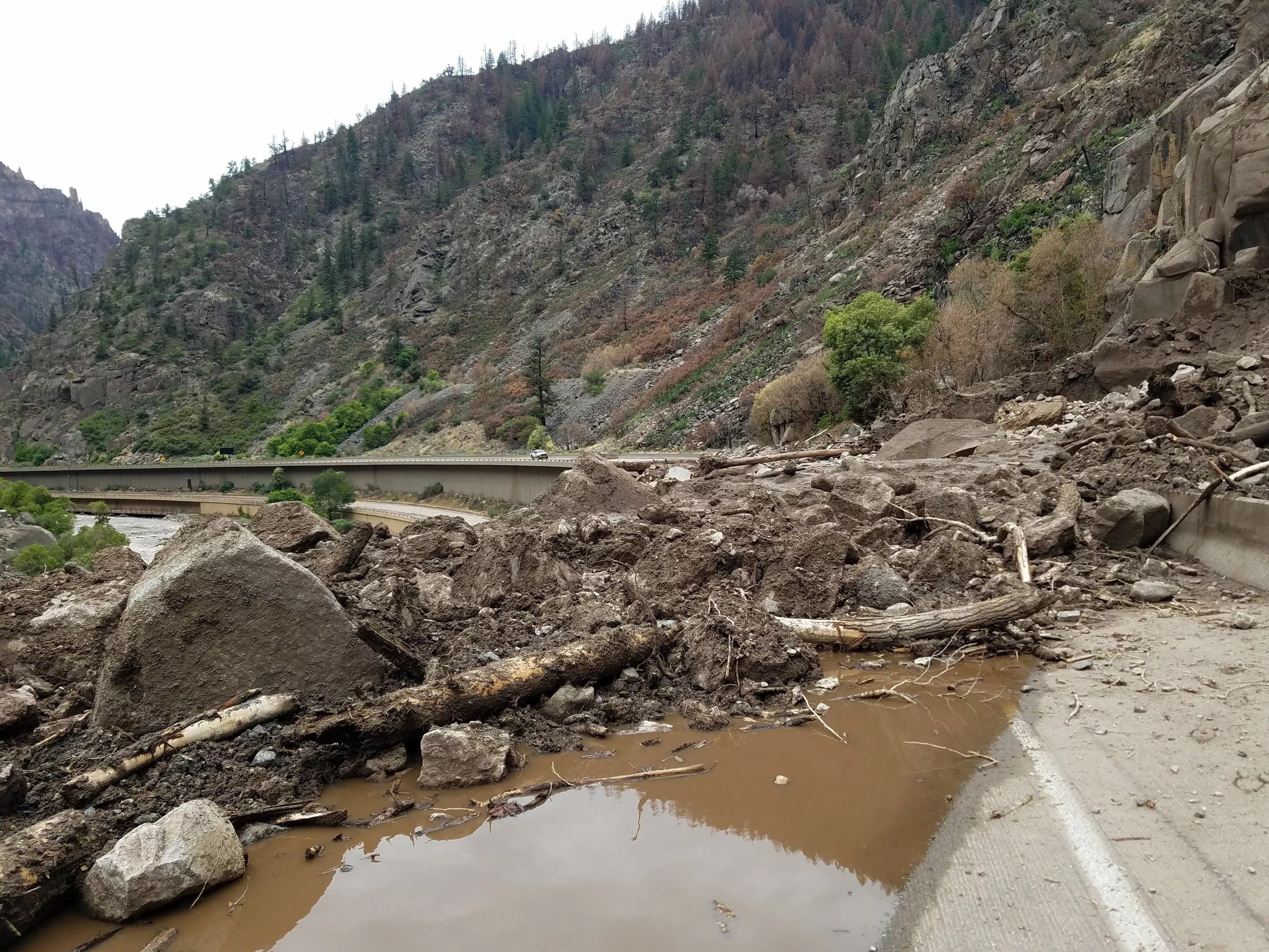
The indefinite closure of Interstate 70 through Glenwood Canyon because of damage caused by mudslides continues to create chaos for travelers desperately searching for options to alternate routes.
But all alternatives are not created equal. On August 6, a Greyhound bus got stuck on Coffee Pot Springs Road, and drivers attempting to take inappropriate vehicles across Independence Pass has led to warnings from the Colorado Department of Transportation. Meanwhile, Governor Jared Polis has declared the affected portion of Glenwood Canyon a disaster area.
And in their comments on our Westword Facebook post of the I-70 closure story, some readers call it much worse. Says David:
Grand Junction is part of Utah now….
Wonders Stephanie:
Why are these people not taking Rabbit Ears Pass? Yes, it is longer but yes, it is also safer.
Replies Thomas:
Maybe because it a single-lane road and heavier trucks can only climb at about 35 mph, which causes a back-up then you have morons who try passing you on a double yellow line with oncoming traffic, and then want trucks to slam on the brakes to let them in. I, for one, won’t do it. Either hit someone head-on or wait behind me, ’cause I am not letting them over
Comments Christopher:
Yesterday coming down Hagerman Pass (a Jeep trail), I had to turn around 5 sedans, 3 crossovers, 3 long wheelbase SUVs and a box truck before they all got stuck in terrain they couldn’t handle. Google/Apple maps sent them all that way because of CDOT’s chicanery in getting Independence Pass marked closed on those apps. What was that about unintended consequences…
Adds Karina:
Google maps needs to be updated with warnings about roads that shouldn’t be used for regular traffic.
And they should be clear about which Cottonwood Pass is an alternative route…and for what. Wonders Cameron:
Is this Cottonwood Pass manageable with SUV and a four-wheeler trailer? I know Cottonwood from Buena Vista is, but curious about the other.
Replies Christine:
No, it is not! Tight switchbacks, no guardrails/shoulders and steep dropoffs. The road itself is only about a car and a half wide…
Notes Maci:
I took Cottonwood Pass in my tiny Mitsubishi Mirage at 1 in the morning. It’s really not that bad, but the road does get a bit skinny right next to a steep cliff at one point.
Concludes Joseph:
They honestly need to spend the money and build a viable alternative route that doesn’t add four hours to the trip. Glenwood Canyon has been a major pain in the ass long before it burned last summer.
Replies Joseph:
It’s one of my favorite places in the whole state. I used to kayak there all the time, but there have been long stretches when it’s been closed due to rockslides in the past. I guess the same thing that makes it beautiful also makes it a pain in the ass.
What do you think the state should do about Glenwood Canyon? Until the road there is reopened, what alternate routes would you recommend?